|
search place name
|
||
Hajang-dong (Korea, North)Hajang-dong is a town in Korea, North. An overview map of the region around Hajang-dong is displayed below.
regional and 3d topo map of Hajang-dong, Korea, North ::
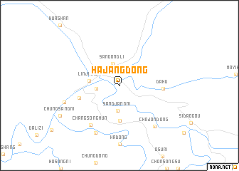
Nearby towns ::
Sangongli (3.5km north) //
Chungdŏng-ni (2.8km west) //
Sangjang-ni (3.9km south) //
Linjiang (3.6km west) //
Osudŏk (5.5km south) //
Ch'angp'yŏng (5.1km west) //
Dahu (5.1km east) //
Changsŏngmun (7.0km south west) //
Sindŏng-ni (7.9km south) //
Ch'ajŏn-dong (7.7km south east) //
Chunggang-ŭp (7.0km west) //
[all distances 'as the bird flies' and approximate] 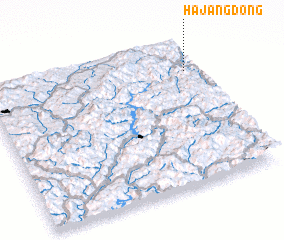 Places with similar names to Hajang-dong, Korea, North ::
// Hajang-dong (KP)
// Hajang-dong (KP)
// Hajang-dong (KP)
// Hajang-dong (KP)
// Hajang-dong (KP)
// Hajŭng-dong (KP)
// Hajung-dong (KP)
// Hojang-dong (KP)
// Hujŏng-dong (KP)
// Hajang-dong (KR)
Disclaimer :: Information on this page comes without warranty of any kind |
||
|
Where is Hajang-dong? Elevation and coordinates ::
Latitude (lat): 41°48'0"N Longitude (lon): 126°57'0"E
Elevation (approx.): 336m (map arrows pan, magnifying glasses zoom) |
||
|
Visiting Hajang-dong? Hotel/Accommodation ::
Book a hotel in Hajang-dong Travel Guide ::
rental cars ::
car rental offers GPS waypoint ::
download a GPX waypoint (PoI) of Hajang-dong for your GPS receiver
|
||