|
search place name
|
||
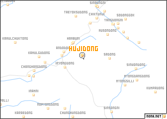
Huji-dong (Chagang, Korea, North)Huji-dong is a town in the Chagang region of Korea, North. An overview map of the region around Huji-dong is displayed below.
regional and 3d topo map of Huji-dong, Korea, North ::
Huji-dong airports ::
The nearest airport is FNJ - Pyongyang Intl, located 234.1 km south of Huji-dong.
Nearby towns ::
Sanyang-dong (4.1km north west) //
Hambu-ri (4.2km north west) //
Iryŏng-dong (3.6km south west) //
Ando-dong (3.8km north west) //
Songhang-ni (3.7km west) //
Sa-dong (4.4km east) //
Musŏn-dong (6.9km north east) //
Yŏksu-ri (8.3km north) //
Songha-ri (6.6km west) //
Yanggang (9.3km north east) //
Yangdŏng-ni (9.5km north east) //
Ongjang-dong (9.2km north east) //
Sinp'ung-ni (10.0km north east) //
[all distances 'as the bird flies' and approximate] 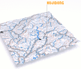 Places with similar names to Huji-dong, Korea, North ::
// Hāji Tangai (PK)
// Haja-dong (KP)
// Haju-dong (KP)
// Hagi-dong (KR)
// Hejiadong (CN)
// Huijiatang (CN)
// Hoa Gi Tong (VN)
// Hejiadong (CN)
// Huajiatang (CN)
// Hoge Donk (NL)
Disclaimer :: Information on this page comes without warranty of any kind |
||
|
Where is Huji-dong? Elevation and coordinates ::
Latitude (lat): 41°12'57"N Longitude (lon): 126°34'17"E
Elevation (approx.): 516m (map arrows pan, magnifying glasses zoom) |
||
|
Visiting Huji-dong? Hotel/Accommodation ::
Book a hotel in Huji-dong Travel Guide ::
rental cars ::
car rental offers GPS waypoint ::
download a GPX waypoint (PoI) of Huji-dong for your GPS receiver
|
||