|
search place name
|
||
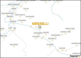
Kangsŏl-li (Hamgyŏng, Korea, North)Kangsŏl-li is a town in the Hamgyŏng region of Korea, North. An overview map of the region around Kangsŏl-li is displayed below.
regional and 3d topo map of Kangsŏl-li, Korea, North ::
Nearby towns ::
Chinhwa-dong (1.8km north west) //
Sa-dong (2.7km south) //
Sango-dong (2.8km south) //
Ku-dong (3.2km south east) //
P'al-tong (3.7km south) //
Ch'il-tong (4.4km south) //
Ch'angnyŏl-lodongjagu (3.5km west) //
Yuk-tong (4.7km south) //
Ch'ayu-dong (6.1km north west) //
P'ungsal-li (6.6km south east) //
Chungi-dong (6.4km south east) //
Ilgŏn-dong (7.0km north west) //
P'yegwan (8.7km south) //
Ch'ilso (9.9km north west) //
[all distances 'as the bird flies' and approximate] 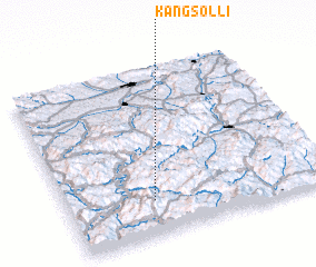 Places with similar names to Kangsŏl-li, Korea, North ::
// Kingsley (US)
// Kingsley (US)
// Kongslia (NO)
// Kunksilla (EE)
// Čanića Selo (BA)
// Conquezuela (ES)
// Kingsley (ZA)
// Kingsley (US)
// Kingsley (US)
// Kingsley (US)
Disclaimer :: Information on this page comes without warranty of any kind |
||
|
Where is Kangsŏl-li? Elevation and coordinates ::
Latitude (lat): 42°12'22"N Longitude (lon): 129°19'37"E
Elevation (approx.): 705m (map arrows pan, magnifying glasses zoom) |
||
|
Visiting Kangsŏl-li? Hotel/Accommodation ::
Book a hotel in Kangsŏl-li Travel Guide ::
rental cars ::
car rental offers GPS waypoint ::
download a GPX waypoint (PoI) of Kangsŏl-li for your GPS receiver
|
||