|
search place name
|
||
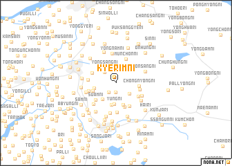
Kyerim-ni (P'yŏngan, Korea, North)Kyerim-ni is a town in the P'yŏngan region of Korea, North. An overview map of the region around Kyerim-ni is displayed below.
regional and 3d topo map of Kyerim-ni, Korea, North ::
Kyerim-ni airports ::
The nearest airport is FNJ - Pyongyang Intl, located 28.1 km south of Kyerim-ni.
Other airports nearby include GMP - Seoul Gimpo (235.1 km south east), Nearby towns ::
Hap'al-li (1.5km south) //
Ch'il-li (1.7km south west) //
Yangch'ŏl-li (2.3km north west) //
Munnam-ni (2.6km north) //
Sangp'al-li (2.4km south east) //
Torhak-kogae (2.7km north west) //
Yongsang-ni (2.9km north west) //
Pugo-ri (3.1km south west) //
Yung-ni (3.5km south) //
Paegam-ni (3.5km south) //
Tŭngnyong-ni (2.8km west) //
Songhyŏllisibil-li (3.7km south) //
Ch'ŏngnyong-ni (2.9km east) //
Yongp'o-ri (3.1km south west) //
Ku-ri (3.1km east) //
Sibi-ri (4.0km south) //
T'ogyo-ri (3.4km north west) //
Munch'ŏn-ni (4.0km north) //
Songhyŏl-li (4.1km south east) //
P'ŏl-mal (3.6km south east) //
Suam-ni (3.8km south west) //
Ŏryong-ni (3.5km west) //
Sinch'ŏl-li (3.6km west) //
Samsim-ni (3.8km south east) //
Sipsam-ni (4.8km south) //
Yongnam-ni (4.8km north) //
Chungo-ri (4.4km south west) //
P'yŏnghwa-ri (4.3km south east) //
Namo-ri (5.0km south) //
[all distances 'as the bird flies' and approximate]  Places with similar names to Kyerim-ni, Korea, North ::
Disclaimer :: Information on this page comes without warranty of any kind |
||
|
Where is Kyerim-ni? Elevation and coordinates ::
Latitude (lat): 39°28'37"N Longitude (lon): 125°39'0"E
Elevation (approx.): 75m (map arrows pan, magnifying glasses zoom) |
||
|
Visiting Kyerim-ni? Hotel/Accommodation ::
Book a hotel in Kyerim-ni Travel Guide ::
rental cars ::
car rental offers GPS waypoint ::
download a GPX waypoint (PoI) of Kyerim-ni for your GPS receiver
|
||