|
search place name
|
||
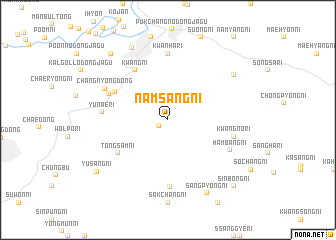
Namsang-ni (Korea, North)Namsang-ni is a town in Korea, North. An overview map of the region around Namsang-ni is displayed below.
regional and 3d topo map of Namsang-ni, Korea, North ::
Namsang-ni airports ::
The nearest airport is FNJ - Pyongyang Intl, located 64.8 km south west of Namsang-ni.
Other airports nearby include GMP - Seoul Gimpo (219.2 km south), Nearby towns ::
Namch'ŏl-li (1.0km south west) //
Ansang-ni (1.7km north) //
Yŏllyu-ri (5.5km north west) //
Kwang-ni (6.3km north west) //
Tongsam-ni (5.7km south west) //
Sinsa-dong (5.8km north west) //
Kwanha-ri (7.4km north) //
Yunae-ri (5.8km west) //
Yonghyŏn-ni (7.5km south) //
Kwangno-ri (6.0km east) //
Hambang-ni (6.3km south east) //
Ch'angnyong-dong (6.5km north west) //
Sanggon-dong (7.6km north east) //
Pukch'ang-ŭp (8.6km north) //
Sangp'yŏng-ni (8.8km south) //
Paegun-dong (8.9km north west) //
Yusang-ni (8.4km south west) //
Sinbong-ni (9.4km south east) //
[all distances 'as the bird flies' and approximate]  Places with similar names to Namsang-ni, Korea, North ::
// Namsang-ni (KP)
// Namsang-ni (KP)
// Namsang-ni (KP)
// Namsŏng-ni (KP)
// Namsŏng-ni (KP)
// Namsong-ni (KP)
// Namsang-ni (KR)
// Namsang-ni (KR)
// Namsŏng-ni (KR)
// Namsŏng-ni (KR)
Disclaimer :: Information on this page comes without warranty of any kind |
||
|
Where is Namsang-ni? Elevation and coordinates ::
Latitude (lat): 39°30'0"N Longitude (lon): 126°20'0"E
Elevation (approx.): 356m (map arrows pan, magnifying glasses zoom) |
||
|
Visiting Namsang-ni? Hotel/Accommodation ::
Book a hotel in Namsang-ni Travel Guide ::
rental cars ::
car rental offers GPS waypoint ::
download a GPX waypoint (PoI) of Namsang-ni for your GPS receiver
|
||