|
search place name
|
||
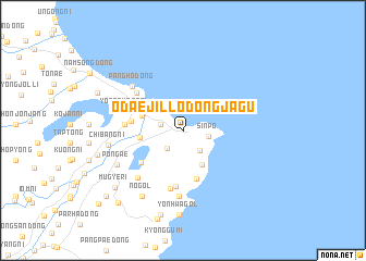
Ŏdaejil-lodongjagu (Hamgyŏng, Korea, North)Ŏdaejil-lodongjagu is a town in the Hamgyŏng region of Korea, North. An overview map of the region around Ŏdaejil-lodongjagu is displayed below.
regional and 3d topo map of Ŏdaejil-lodongjagu, Korea, North ::
Nearby towns ::
Songhŭng-dong (1.8km west) //
K'ŭn-gol (2.2km south west) //
Karaenaru (2.5km south east) //
Sinp'o (2.1km east) //
Magŭn'gae (3.3km north west) //
Chisŏgumi (3.8km south east) //
Sujung-dong (3.4km north west) //
An'gyo (3.4km west) //
Maebawi (5.1km south) //
Chungp'yŏng (4.1km west) //
Iu-dong (4.6km south west) //
Puam-dong (5.8km south) //
Sangp'yŏng (4.5km west) //
Hoyang-dong (5.3km north west) //
Chaech'anggumi (6.1km south) //
Yongp'yŏng-ni (4.9km north west) //
Ijin-gol (6.0km south west) //
Koraegumi (6.8km south) //
Pangho-dong (6.0km north west) //
Pŏn'gae (6.1km south west) //
Chibang-ni (6.0km west) //
No-gol (7.5km south west) //
Yŏnhwagol (8.7km south) //
Chagŭn'gumi (8.8km south) //
Mugye-ri (7.8km south west) //
P'algyŏngdae-ri (7.1km west) //
Ch'ŏllyŏn (7.6km north west) //
Tan'gu (8.9km south west) //
Hoeryong-dong (9.0km south west) //
[all distances 'as the bird flies' and approximate] 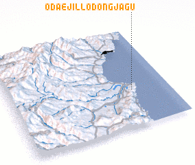 Places with similar names to Ŏdaejil-lodongjagu, Korea, North :: Disclaimer :: Information on this page comes without warranty of any kind |
||
|
Where is Ŏdaejil-lodongjagu? Elevation and coordinates ::
Latitude (lat): 41°22'40"N Longitude (lon): 129°46'14"E
Elevation (approx.): 4m (map arrows pan, magnifying glasses zoom) |
||
|
Visiting Ŏdaejil-lodongjagu? Hotel/Accommodation ::
Book a hotel in Ŏdaejil-lodongjagu Travel Guide ::
rental cars ::
car rental offers GPS waypoint ::
download a GPX waypoint (PoI) of Ŏdaejil-lodongjagu for your GPS receiver
|
||