|
search place name
|
||
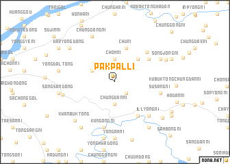
Pakp'al-li (Korea, North)Pakp'al-li is a town in Korea, North. An overview map of the region around Pakp'al-li is displayed below.
regional and 3d topo map of Pakp'al-li, Korea, North ::
Pakp'al-li airports ::
The nearest airport is FNJ - Pyongyang Intl, located 133.4 km south east of Pakp'al-li.
Nearby towns ::
Kwangdaegok (2.3km south east) //
Tonggong-ni (2.3km south east) //
Chungdan-ni (3.6km south) //
Chŏm-ni (3.7km north) //
Sanyang-ni (3.4km north west) //
Yang-ni (4.7km north east) //
Ch'u-ri (5.7km north) //
Samha-ri (5.6km north east) //
Ch'unsan-ni (6.2km south east) //
Samhadong-sambong-ni (6.3km north east) //
Hudo-ri (7.5km south) //
Kŭmgong-ni (7.5km south) //
Susang-ni (6.0km east) //
Illyŏng-ni (6.9km south east) //
Sangsam-ni (7.0km south east) //
Chunggong-ni (7.9km north) //
Chunggong-ni (6.8km north east) //
Taemun-ni (6.8km west) //
Songjŏng-ni (7.3km north east) //
Kwanbuk-tong (8.0km south west) //
Milbak-kol (8.5km south east) //
P'odo-ri (8.5km south west) //
Waryong-dong (7.9km north west) //
Sambyŏng-ni (8.3km south east) //
[all distances 'as the bird flies' and approximate]  Places with similar names to Pakp'al-li, Korea, North ::
Disclaimer :: Information on this page comes without warranty of any kind |
||
|
Where is Pakp'al-li? Elevation and coordinates ::
Latitude (lat): 40°11'0"N Longitude (lon): 124°44'0"E
Elevation (approx.): 261m (map arrows pan, magnifying glasses zoom) |
||
|
Visiting Pakp'al-li? Hotel/Accommodation ::
Book a hotel in Pakp'al-li Travel Guide ::
rental cars ::
car rental offers GPS waypoint ::
download a GPX waypoint (PoI) of Pakp'al-li for your GPS receiver
|
||