|
search place name
|
||
Sangch'irhyang (Yanggang, Korea, North)Sangch'irhyang is a town in the Yanggang region of Korea, North. An overview map of the region around Sangch'irhyang is displayed below.
regional and 3d topo map of Sangch'irhyang, Korea, North ::
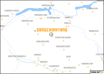
Nearby towns ::
Hwajŏn-dong (3.6km south west) //
Ch'irhyang-dong (3.4km east) //
Yŏngjŏ (4.0km west) //
P'yŏngbugŭn (5.9km north) //
Sangdan-dong (5.6km south east) //
Sammak-tong (5.5km north east) //
Noŭl-li (6.0km north east) //
Pan'gok-ch'on (7.5km north west) //
Migam-ni (7.5km north west) //
P'abal-li (7.6km north east) //
Sang-ni (8.4km south west) //
Ch'ŏlsal-lodongjagu (9.1km south west) //
Ch'ŏngyong-ch'on (8.1km north west) //
Samp'o-ch'on (8.1km north west) //
Idŏk (9.5km south east) //
T'ongp'a-dong (10.2km south west) //
[all distances 'as the bird flies' and approximate] 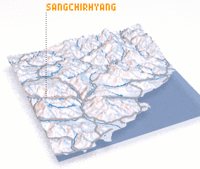 Places with similar names to Sangch'irhyang, Korea, North :: Disclaimer :: Information on this page comes without warranty of any kind |
||
|
Where is Sangch'irhyang? Elevation and coordinates ::
Latitude (lat): 40°36'27"N Longitude (lon): 128°7'43"E
Elevation (approx.): 1345m (map arrows pan, magnifying glasses zoom) |
||
|
Visiting Sangch'irhyang? Hotel/Accommodation ::
Book a hotel in Sangch'irhyang Travel Guide ::
rental cars ::
car rental offers GPS waypoint ::
download a GPX waypoint (PoI) of Sangch'irhyang for your GPS receiver
|
||