|
search place name
|
||
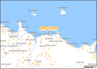
Sang-dong (Kangwŏn, Korea, North)Sang-dong is a town in the Kangwŏn region of Korea, North. An overview map of the region around Sang-dong is displayed below.
regional and 3d topo map of Sang-dong, Korea, North ::
Sang-dong airports ::
The nearest airport is SHO - Sokch'o Sokcho, located 142.9 km south east of Sang-dong.
Other airports nearby include FNJ - Pyongyang Intl (164.6 km west), GMP - Seoul Gimpo (189.2 km south), SSN - Seoul East Seoul Ab (193.1 km south), KAG - Kangnung Gangneung (195.7 km south east), Nearby towns ::
Yŏndong-ni (0.5km south) //
Sin-dong (1.0km south east) //
Yŏmjuhyŏn (1.5km south east) //
Sangmi-ri (2.5km south) //
Ha-dong (2.1km east) //
Wŏlp'o-ri (2.5km south west) //
Nangsŏng-ni (2.5km west) //
Sangŭm-ni (2.7km south east) //
Sŏndol-gol (3.2km south west) //
Hapchil-li (2.9km east) //
Ch'osa-dong (3.9km south) //
Wŏllang-ni (3.6km south west) //
Sinwagyo (4.0km south west) //
Songhyŏn (3.6km east) //
Paekhak-tong (4.2km south east) //
Pongch'on (3.9km south east) //
Wŏnp'yŏng (5.2km south) //
Unsu-gol (5.8km south) //
Ogye-ri (5.7km south) //
Sŏngbung-ni (4.8km west) //
Yulp'o (6.9km south) //
Ungjil-li (5.8km south east) //
Songyang-ni (5.9km south east) //
Hawa-ri (7.4km south) //
Nap'yŏng-ni (6.2km south west) //
Yongch'ŏl-li (6.0km west) //
Sangsago-ri (6.4km south west) //
Chungp'yŏng-ni (7.7km south) //
Utchinbul (6.4km south east) //
[all distances 'as the bird flies' and approximate] 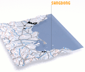 Places with similar names to Sang-dong, Korea, North ::
// Sangadaung (MM)
// Sa-ngawdung (MM)
// Sina Gahtawng (MM)
// Sungai Tinggi (MY)
// Sungai Udang (MY)
// Singatanga (BF)
// Songotongo (GT)
// Sungaitengah (ID)
// Sungaiudang (ID)
// Sangatanga (GA)
Disclaimer :: Information on this page comes without warranty of any kind |
||
|
Where is Sang-dong? Elevation and coordinates ::
Latitude (lat): 39°8'52"N Longitude (lon): 127°34'20"E
Elevation (approx.): 17m (map arrows pan, magnifying glasses zoom) |
||
|
Visiting Sang-dong? Hotel/Accommodation ::
Book a hotel in Sang-dong Travel Guide ::
rental cars ::
car rental offers GPS waypoint ::
download a GPX waypoint (PoI) of Sang-dong for your GPS receiver
|
||