|
search place name
|
||
Sangi-dong (Hamgyŏng, Korea, North)Sangi-dong is a town in the Hamgyŏng region of Korea, North. An overview map of the region around Sangi-dong is displayed below.
regional and 3d topo map of Sangi-dong, Korea, North ::
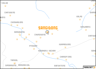
Nearby towns ::
Chungil-tong (1.2km east) //
Chungi-dong (2.5km south west) //
Sangil-tong (3.3km north east) //
P'ungsal-li (4.3km south west) //
Ch'ayu-ri (7.2km south) //
Ku-dong (5.5km west) //
Sinch'am (7.4km south) //
Koch'am (7.5km south) //
Kŏsamoru (7.5km south) //
P'yegwan (6.9km south west) //
Kŭmp'ae-dong (7.0km south east) //
P'al-tong (6.4km west) //
[all distances 'as the bird flies' and approximate] 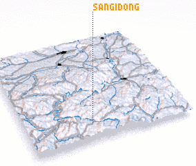 Places with similar names to Sangi-dong, Korea, North ::
// Sangi-dong (KP)
// Sanje-dong (KP)
// Sanjŏ-dong (KP)
// Sanjŏ-dong (KP)
// Sanjŏ-dong (KP)
// Sin'gi-dong (KP)
// Sin'gi-dong (KP)
// Songi-dong (KP)
// Sin'gi-dong (KR)
// Sin'gi-dong (KR)
Disclaimer :: Information on this page comes without warranty of any kind |
||
|
Where is Sangi-dong? Elevation and coordinates ::
Latitude (lat): 42°11'0"N Longitude (lon): 129°25'0"E
Elevation (approx.): 711m (map arrows pan, magnifying glasses zoom) |
||
|
Visiting Sangi-dong? Hotel/Accommodation ::
Book a hotel in Sangi-dong Travel Guide ::
rental cars ::
car rental offers GPS waypoint ::
download a GPX waypoint (PoI) of Sangi-dong for your GPS receiver
|
||