|
search place name
|
||
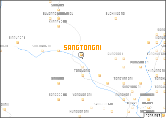
Sangt'ong-ni (Hamgyŏng, Korea, North)Sangt'ong-ni is a town in the Hamgyŏng region of Korea, North. An overview map of the region around Sangt'ong-ni is displayed below.
regional and 3d topo map of Sangt'ong-ni, Korea, North ::
Sangt'ong-ni airports ::
The nearest airport is FNJ - Pyongyang Intl, located 173.9 km south west of Sangt'ong-ni.
Other airports nearby include SHO - Sokch'o Sokcho (242.6 km south east), Nearby towns ::
Sinsang-ni (1.9km south) //
Tongjŏng (3.7km south) //
Solp'at-maŭl (4.7km south east) //
Hat'ong-ni (4.6km north west) //
P'ungsŏ-ri (5.7km east) //
Samgŏ-ri (7.0km south west) //
Ssangsong-ni (7.0km south east) //
Kwanp'yŏng (8.5km north west) //
[all distances 'as the bird flies' and approximate] 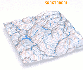 Places with similar names to Sangt'ong-ni, Korea, North ::
// Sangdŏng-ni (KP)
// Sangdŏng-ni (KP)
// Sangdong-ni (KP)
// Sangdong-ni (KP)
// Sŏngdang-ni (KP)
// Sŏngdong-ni (KP)
// Sŏngdong-ni (KP)
// Sŏngdong-ni (KP)
// Sŏngdong-ni (KP)
// Sŏngdong-ni (KP)
Disclaimer :: Information on this page comes without warranty of any kind |
||
|
Where is Sangt'ong-ni? Elevation and coordinates ::
Latitude (lat): 40°6'0"N Longitude (lon): 127°21'0"E
Elevation (approx.): 122m (map arrows pan, magnifying glasses zoom) |
||
|
Visiting Sangt'ong-ni? Hotel/Accommodation ::
Book a hotel in Sangt'ong-ni Travel Guide ::
rental cars ::
car rental offers GPS waypoint ::
download a GPX waypoint (PoI) of Sangt'ong-ni for your GPS receiver
|
||