|
search place name
|
||
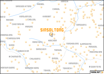
Sinsŏl-tong (Hamgyŏng, Korea, North)Sinsŏl-tong is a town in the Hamgyŏng region of Korea, North. An overview map of the region around Sinsŏl-tong is displayed below.
regional and 3d topo map of Sinsŏl-tong, Korea, North ::
Nearby towns ::
Namjik (0.9km south east) //
Pukchak (1.1km north east) //
Wa-dong (1.7km north) //
Hoe-ch'on (2.4km south) //
Namsŏk (2.5km north) //
Sin'gye-dong (2.9km south west) //
Tae-dong (2.8km south west) //
Wŏnsunp'o (3.4km south) //
Puam-ni (3.3km north) //
Yong-dong (3.4km south east) //
Tŏm-gol (3.2km east) //
Ch'ŏngnyong-ni (3.6km north east) //
So-dong (3.8km south west) //
Yŏndae-dong (3.3km east) //
Tŏngnyangp'o (4.2km south east) //
Yongso (3.9km north east) //
Nosang (4.4km north east) //
Kukhwa-dong (4.2km south east) //
Namgyŏng (4.9km south west) //
Kosŏng-ni (5.0km north east) //
Hanaep'o (5.3km north east) //
Sambat-kol (5.8km north) //
Koch'am-ni (5.3km south east) //
Ssanggae-gol (6.3km south) //
Yo-gol (6.0km north) //
Tari-gol (6.2km south) //
Kkaebat (6.4km north) //
Yongbong-ch'on (6.4km south) //
Sang-ch'on (6.2km south west) //
[all distances 'as the bird flies' and approximate] 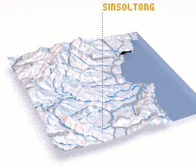 Places with similar names to Sinsŏl-tong, Korea, North ::
// Sinsul-tong (KR)
Disclaimer :: Information on this page comes without warranty of any kind |
||
|
Where is Sinsŏl-tong? Elevation and coordinates ::
Latitude (lat): 41°7'29"N Longitude (lon): 129°20'15"E
Elevation (approx.): 348m (map arrows pan, magnifying glasses zoom) |
||
|
Visiting Sinsŏl-tong? Hotel/Accommodation ::
Book a hotel in Sinsŏl-tong Travel Guide ::
rental cars ::
car rental offers GPS waypoint ::
download a GPX waypoint (PoI) of Sinsŏl-tong for your GPS receiver
|
||