|
search place name
|
||
So-dong (Hamgyŏng, Korea, North)So-dong is a town in the Hamgyŏng region of Korea, North. An overview map of the region around So-dong is displayed below.
regional and 3d topo map of So-dong, Korea, North ::
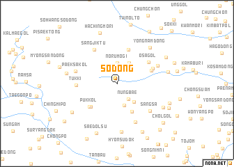
Nearby towns ::
Isudŏk (2.3km north) //
Nŭngbae (2.8km south east) //
Norumogi (3.3km north) //
Chaegae-gol (3.6km south) //
Chik-tong (3.6km north east) //
Ŏmhyang-gol (3.6km south east) //
Paegam-dong (4.9km south) //
Paegam-dong (4.9km south) //
Puk-kol (4.9km south west) //
Pokchang-dong (5.6km north) //
Puk-kol (5.0km south west) //
Pohwabo (4.6km north east) //
Osa-gol (5.1km north east) //
Poam (4.9km north east) //
Sangjiktu (6.0km north west) //
Tŭkki (4.9km west) //
Kwangha-dong (6.6km south) //
Sangsa (5.9km south east) //
Paeksa-kol (5.4km west) //
Hu-dong (5.6km north east) //
Sech'odŏk (7.8km south) //
Yongnam-dong (7.0km north east) //
Maje (6.3km west) //
Ŭnsan-dong (6.4km east) //
Ŏmgwang-ni (6.8km south east) //
Sinun-dong (7.1km south west) //
Hachingmŏri (8.4km north) //
Saedolsu (8.4km south) //
Sambo-dong (8.4km south) //
[all distances 'as the bird flies' and approximate] 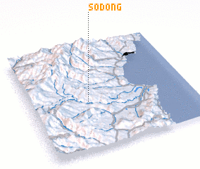 Places with similar names to So-dong, Korea, North ::
Disclaimer :: Information on this page comes without warranty of any kind |
||
|
Where is So-dong? Elevation and coordinates ::
Latitude (lat): 41°28'6"N Longitude (lon): 129°21'59"E
Elevation (approx.): 925m (map arrows pan, magnifying glasses zoom) |
||
|
Visiting So-dong? Hotel/Accommodation ::
Book a hotel in So-dong Travel Guide ::
rental cars ::
car rental offers GPS waypoint ::
download a GPX waypoint (PoI) of So-dong for your GPS receiver
|
||