|
search place name
|
||
Sŏkkol-Hadan (Korea, North)Sŏkkol-Hadan is a town in Korea, North. An overview map of the region around Sŏkkol-Hadan is displayed below.
regional and 3d topo map of Sŏkkol-Hadan, Korea, North ::

Sŏkkol-Hadan airports ::
The nearest airport is FNJ - Pyongyang Intl, located 73.1 km south east of Sŏkkol-Hadan.
Nearby towns ::
Chosan-dong (0.0km north) //
Kwaksan-ŭp (1.4km south) //
Sŏktong-ni (1.7km north east) //
Yongha-ri (1.9km north west) //
Namdandongsangdan (2.3km south west) //
Namdal-li (2.7km south) //
Hou-ri (2.4km south east) //
Sŏkkolsangdan (2.6km north east) //
Namsal-li (3.1km south) //
T'onggyŏng-ni (3.2km north) //
Kŭndong-ni (3.4km north) //
Ŏmjang-ni (2.8km south west) //
So-gol (3.0km south east) //
Chuam (3.3km north west) //
Yongsal-li (3.9km north) //
Ch'osang (3.2km west) //
Ch'ojang-ni (3.4km south west) //
Ch'oha (3.3km west) //
Tangha-ri (3.7km north east) //
Songhyŏn (4.1km south east) //
Hadal-li (4.3km south) //
Wŏnha-ri (4.1km south east) //
Hwanghang-ni (4.2km north west) //
Yangji (5.0km south) //
Nosang-dong (5.3km south) //
Kusŏk (4.9km south east) //
Samgon-ni (4.7km south west) //
Noha-dong (5.5km south) //
Noha-ri (5.4km south) //
[all distances 'as the bird flies' and approximate] 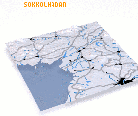 Places with similar names to Sŏkkol-Hadan, Korea, North :: Disclaimer :: Information on this page comes without warranty of any kind |
||
|
Where is Sŏkkol-Hadan? Elevation and coordinates ::
Latitude (lat): 39°42'0"N Longitude (lon): 125°5'0"E
Elevation (approx.): 15m (map arrows pan, magnifying glasses zoom) |
||
|
Visiting Sŏkkol-Hadan? Hotel/Accommodation ::
Book a hotel in Sŏkkol-Hadan Travel Guide ::
rental cars ::
car rental offers GPS waypoint ::
download a GPX waypoint (PoI) of Sŏkkol-Hadan for your GPS receiver
|
||