|
search place name
|
||
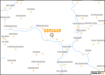
Songdun (Hamgyŏng, Korea, North)Songdun is a town in the Hamgyŏng region of Korea, North. An overview map of the region around Songdun is displayed below.
regional and 3d topo map of Songdun, Korea, North ::
Songdun airports ::
The nearest airport is FNJ - Pyongyang Intl, located 104.4 km south west of Songdun.
Other airports nearby include SHO - Sokch'o Sokcho (228.4 km south east), Nearby towns ::
P'yŏngwŏn-ni (1.4km south east) //
Songha-dong (1.9km south west) //
Ilgŏn-dong (2.9km east) //
Unhŭng-dong (4.3km north west) //
Pae-ch'on (5.7km south east) //
Sinhŭng-ni (6.4km south west) //
Chungdongsan-ni (6.7km south east) //
Tongsan-ni (6.7km south east) //
Misam-ni (7.5km south west) //
Subang-dong (7.0km north west) //
Yodŏg-ŭp (6.9km east) //
[all distances 'as the bird flies' and approximate] 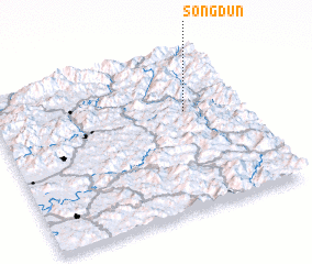 Places with similar names to Songdun, Korea, North ::
// Saungdan (MM)
// Saungdun (MM)
// Snaketown (US)
// Sankt Anna (AT)
// Sankt Anna (AT)
// Sankt Anna (AT)
// Sankt Anna (AT)
// Sankt Anna (DE)
// Sankt Anna (DE)
// Sankt Anna (DE)
Disclaimer :: Information on this page comes without warranty of any kind |
||
|
Where is Songdun? Elevation and coordinates ::
Latitude (lat): 39°37'17"N Longitude (lon): 126°46'7"E
Elevation (approx.): 304m (map arrows pan, magnifying glasses zoom) |
||
|
Visiting Songdun? Hotel/Accommodation ::
Book a hotel in Songdun Travel Guide ::
rental cars ::
car rental offers GPS waypoint ::
download a GPX waypoint (PoI) of Songdun for your GPS receiver
|
||