|
search place name
|
||
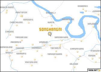
Songhang-ni (Hamgyŏng, Korea, North)Songhang-ni is a town in the Hamgyŏng region of Korea, North. An overview map of the region around Songhang-ni is displayed below.
regional and 3d topo map of Songhang-ni, Korea, North ::
Songhang-ni airports ::
The nearest airport is VVO - Vladivostok Knevichi, located 173.6 km north east of Songhang-ni.
Nearby towns ::
Yongyŏl-lodongjagu (3.5km south) //
Kŭmch'i (4.0km north) //
Ŭndŏg-ŭp (3.8km south west) //
Sangsam-dong (3.4km south east) //
Aoji-ri (4.2km south east) //
Haksong-ni (4.7km south east) //
T'aeyang-ni (5.8km south) //
Obong-nodongjagu (5.8km south west) //
Kwirang-ni (6.7km south west) //
Sinasal-li (7.5km north) //
Sang-ch'on (7.6km south) //
Yongsŏng-dong (8.0km south) //
Paegan-dong (7.1km north east) //
Hayŏp'yŏng-ni (6.6km east) //
Osong (8.4km south east) //
Song-dong (7.7km north west) //
Songsang-dong (9.8km south west) //
[all distances 'as the bird flies' and approximate] 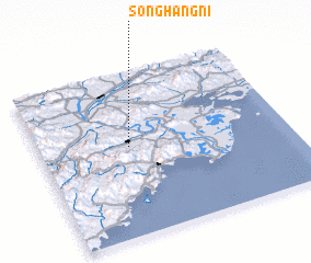 Places with similar names to Songhang-ni, Korea, North ::
// Sanghŭng-ni (KP)
// Sanghŭng-ni (KP)
// Sanghŭng-ni (KP)
// Sanghŭng-ni (KP)
// Sanghŭng-ni (KP)
// Sanghŭng-ni (KP)
// Songhang-ni (KP)
// Songhang-ni (KP)
// Songhang-ni (KP)
// Songhang-ni (KP)
Disclaimer :: Information on this page comes without warranty of any kind |
||
|
Where is Songhang-ni? Elevation and coordinates ::
Latitude (lat): 42°32'52"N Longitude (lon): 130°21'46"E
Elevation (approx.): 36m (map arrows pan, magnifying glasses zoom) |
||
|
Visiting Songhang-ni? Hotel/Accommodation ::
Book a hotel in Songhang-ni Travel Guide ::
rental cars ::
car rental offers GPS waypoint ::
download a GPX waypoint (PoI) of Songhang-ni for your GPS receiver
|
||