|
search place name
|
||
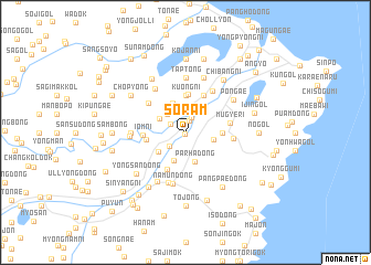
Sŏram (Hamgyŏng, Korea, North)Sŏram is a town in the Hamgyŏng region of Korea, North. An overview map of the region around Sŏram is displayed below.
regional and 3d topo map of Sŏram, Korea, North ::
Nearby towns ::
Yanggyŏl-li (0.2km south) //
Sunam-ni (1.2km north) //
Ha-ch'on (1.6km north) //
Naruam (1.4km north west) //
Yongch'ŏn-dong (1.8km south west) //
Yonggang-ni (2.3km north west) //
Hanam-dong (2.6km north east) //
Habarha (2.3km east) //
Subuk (2.4km north west) //
Parha-dong (3.0km south) //
Yongnam-dong (3.0km south) //
Ponggang-ni (3.1km north) //
Yongju-dong (2.8km south west) //
Hoeryong-dong (2.8km east) //
Kuŏng-ni (3.7km north) //
Songp'yŏng-ni (3.8km north) //
Haŏm-dong (3.0km west) //
Kangu (4.0km south) //
Sang-ni (4.0km north) //
Iŏm-ni (3.2km west) //
Mugye-ri (3.6km east) //
Sangyŏn (4.1km north west) //
Tan'gu (3.7km east) //
P'algyŏngdae-ri (4.7km north east) //
Chungyŏn (4.9km north west) //
Namŭn-dong (5.3km south) //
Honam-ni (5.3km south) //
T'ap-tong (5.6km north) //
Homun'gol (4.2km west) //
[all distances 'as the bird flies' and approximate]  Places with similar names to Sŏram, Korea, North ::
Disclaimer :: Information on this page comes without warranty of any kind |
||
|
Where is Sŏram? Elevation and coordinates ::
Latitude (lat): 41°19'0"N Longitude (lon): 129°40'0"E
Elevation (approx.): 17m (map arrows pan, magnifying glasses zoom) |
||
|
Visiting Sŏram? Hotel/Accommodation ::
Book a hotel in Sŏram Travel Guide ::
rental cars ::
car rental offers GPS waypoint ::
download a GPX waypoint (PoI) of Sŏram for your GPS receiver
|
||