|
search place name
|
||
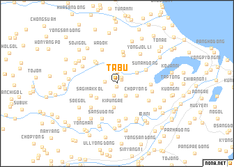
T'abu (Hamgyŏng, Korea, North)T'abu is a town in the Hamgyŏng region of Korea, North. An overview map of the region around T'abu is displayed below.
regional and 3d topo map of T'abu, Korea, North ::
Nearby towns ::
Taemun-dong (0.5km south) //
Chasan-dong (0.8km north east) //
Soyo-ri (1.1km north east) //
Sangsoyo (1.9km north) //
Sangmyŏng-gol (1.5km west) //
Kanbu (2.0km south) //
Tae-dong (2.2km south east) //
Chuch'onjonjang (3.0km north east) //
Ka-dong (3.0km north east) //
Ch'op'yŏng (3.1km south east) //
Taemal-ch'on (3.1km south east) //
Kip'ŭn'gae (3.8km south) //
Nŭngjiam (3.3km south west) //
Hasoegol (3.7km south west) //
Sagimak-kol (3.7km south west) //
Chuch'onhujang (4.6km north) //
Iramdongyongjŏn'gok (4.1km north west) //
Iram-dong (4.4km north west) //
Sunam-dong (4.1km north east) //
Yongjŏndongyongjŏn'gok (5.1km north) //
Changyŏn-gol (4.0km east) //
Manbop'o (4.9km south west) //
Sujikkol (4.9km south west) //
Sangyŏn (4.7km south east) //
Sambong (5.7km south) //
Chungyŏn (4.5km east) //
Nae-gol (5.9km south) //
Wadŏk (5.7km north) //
Yongjŏl-li (5.5km north east) //
[all distances 'as the bird flies' and approximate] 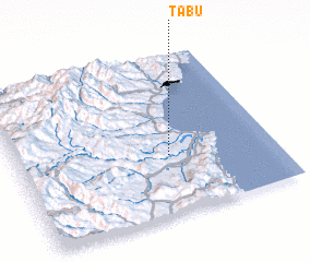 Places with similar names to T'abu, Korea, North ::
Disclaimer :: Information on this page comes without warranty of any kind |
||
|
Where is T'abu? Elevation and coordinates ::
Latitude (lat): 41°22'3"N Longitude (lon): 129°35'16"E
Elevation (approx.): 61m (map arrows pan, magnifying glasses zoom) |
||
|
Visiting T'abu? Hotel/Accommodation ::
Book a hotel in T'abu Travel Guide ::
rental cars ::
car rental offers GPS waypoint ::
download a GPX waypoint (PoI) of T'abu for your GPS receiver
|
||