|
search place name
|
||
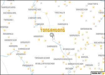
Tongam-dong (Hamgyŏng, Korea, North)Tongam-dong is a town in the Hamgyŏng region of Korea, North. An overview map of the region around Tongam-dong is displayed below.
regional and 3d topo map of Tongam-dong, Korea, North ::
Nearby towns ::
P'yŏng-ch'on (0.5km south east) //
Sangwŏl (0.8km north east) //
Sŏdang-ch'on (2.4km south east) //
Tong-ch'on (2.3km south west) //
Tongdae (3.3km south east) //
Cham-dong (4.3km south) //
Wadong-ni (3.8km west) //
Ch'ŏnandŏgi (4.2km north west) //
Kwan-dong (4.7km north east) //
Su-ch'on (4.8km north west) //
Sinan-ch'on (6.9km north east) //
Kaehwasan (6.3km north west) //
Namsandŏk (7.4km south east) //
Sinp'yŏng-ni (6.8km north west) //
P'yŏng-ch'on (7.0km south east) //
Tŏkch'ollip'o-ch'on (7.1km south east) //
Unch'ŏl-li (7.2km south east) //
Sinp'ung-ni (6.2km east) //
Taech'uja (8.0km north) //
Panghak-tong (6.4km east) //
Ch'angp'yŏng (7.5km north west) //
P'ogŏ-dong (8.8km north) //
Tangdong-ch'on (8.8km south) //
Kaŭngnisang-ch'on (9.3km south) //
Songhang (8.5km south east) //
Yongjam-ni (8.9km south east) //
Songp'a-ch'on (10.0km north west) //
[all distances 'as the bird flies' and approximate]  Places with similar names to Tongam-dong, Korea, North ::
Disclaimer :: Information on this page comes without warranty of any kind |
||
|
Where is Tongam-dong? Elevation and coordinates ::
Latitude (lat): 40°39'20"N Longitude (lon): 128°55'0"E
Elevation (approx.): 112m (map arrows pan, magnifying glasses zoom) |
||
|
Visiting Tongam-dong? Hotel/Accommodation ::
Book a hotel in Tongam-dong Travel Guide ::
rental cars ::
car rental offers GPS waypoint ::
download a GPX waypoint (PoI) of Tongam-dong for your GPS receiver
|
||