|
search place name
|
||
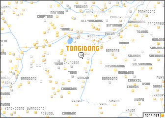
T'ongi-dong (Hamgyŏng, Korea, North)T'ongi-dong is a town in the Hamgyŏng region of Korea, North. An overview map of the region around T'ongi-dong is displayed below.
regional and 3d topo map of T'ongi-dong, Korea, North ::
Nearby towns ::
San-dong (1.0km east) //
Sin'gyo (1.2km south east) //
Hadae-dong (1.4km north) //
Myŏngnam-ni (1.5km north east) //
Myŏngch'ŏn (2.1km south) //
Sangsa-dong (2.9km south) //
Chungsan (2.5km south west) //
Sansŏng-dong (2.9km north east) //
Toktŏk (2.9km south east) //
Yongsan-dong (3.1km north west) //
Sŏnggi (3.7km north east) //
Imat'o (3.1km west) //
Paengnong-ni (3.2km west) //
Myosan (4.0km north) //
Samch'ŏng-dong (3.2km east) //
Yusin (4.3km south west) //
Yŏndŏk (3.7km south west) //
Ipsŏng-ni (4.7km north east) //
Yujŏn (4.0km north west) //
Yujŏn (3.9km west) //
Pak-tong (4.2km north east) //
Pongam (5.2km south) //
Ipsŏkchang (4.8km north east) //
Unp'o (4.5km north east) //
Sinch'ang-dong (5.3km north) //
Chigyŏng-dong (4.7km north west) //
Puam-dong (4.1km west) //
Yusin (4.5km south west) //
Madŭng-gol (5.4km south west) //
[all distances 'as the bird flies' and approximate]  Places with similar names to T'ongi-dong, Korea, North ::
Disclaimer :: Information on this page comes without warranty of any kind |
||
|
Where is T'ongi-dong? Elevation and coordinates ::
Latitude (lat): 41°12'7"N Longitude (lon): 129°32'40"E
Elevation (approx.): 128m (map arrows pan, magnifying glasses zoom) |
||
|
Visiting T'ongi-dong? Hotel/Accommodation ::
Book a hotel in T'ongi-dong Travel Guide ::
rental cars ::
car rental offers GPS waypoint ::
download a GPX waypoint (PoI) of T'ongi-dong for your GPS receiver
|
||