|
search place name
|
||
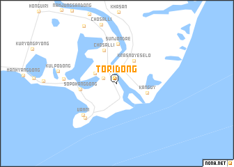
T'ori-dong (Najin Sŏnbong-si, Korea, North)T'ori-dong is a town in the Najin Sŏnbong-si region of Korea, North. An overview map of the region around T'ori-dong is displayed below.
regional and 3d topo map of T'ori-dong, Korea, North ::
T'ori-dong airports ::
The nearest airport is VVO - Vladivostok Knevichi, located 171.4 km north east of T'ori-dong.
Nearby towns ::
Hwangŏp'o (1.8km north west) //
Hongsangp'o (3.0km north west) //
(( Krasnoye Selo )) (4.1km north east) //
(( Kanguy )) (3.9km south east) //
Chosal-li (5.5km north) //
Sŏp'ohang-dong (4.4km west) //
Sunjŏndae (6.3km north) //
Uam-ni (6.5km south west) //
Tongsŏsura-dong (6.7km south west) //
Kulp'o-dong (6.4km west) //
[all distances 'as the bird flies' and approximate]  Places with similar names to T'ori-dong, Korea, North ::
// Trattenegg (AT)
// Tretting (DE)
// Dorotynka (PL)
// Tertanga (ES)
// Dertniki (RU)
// Dretenka (RU)
// Darreh Tang (IR)
// Darreh Tang (IR)
// Duaridanga (BD)
// Dourtenga (BF)
Disclaimer :: Information on this page comes without warranty of any kind |
||
|
Where is T'ori-dong? Elevation and coordinates ::
Latitude (lat): 42°19'8"N Longitude (lon): 130°39'2"E
Elevation (approx.): 7m (map arrows pan, magnifying glasses zoom) |
||
|
Visiting T'ori-dong? Hotel/Accommodation ::
Book a hotel in T'ori-dong Travel Guide ::
rental cars ::
car rental offers GPS waypoint ::
download a GPX waypoint (PoI) of T'ori-dong for your GPS receiver
|
||