|
search place name
|
||
Turianji (Hamgyŏng, Korea, North)Turianji is a town in the Hamgyŏng region of Korea, North. An overview map of the region around Turianji is displayed below.
regional and 3d topo map of Turianji, Korea, North ::
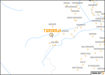
Nearby towns ::
Taech'ŏnp'o (1.7km south east) //
Kyŏlsu (2.2km south) //
Namp'yŏng-dong (2.8km south) //
Ha-ch'on (2.7km south) //
Haksan (3.9km north) //
Soch'ŏnp'o (3.3km north east) //
Namp'yŏngdongch'op'yŏng (5.3km east) //
Hajangp'o (5.7km east) //
Namuguksa (6.5km east) //
Sobokki (7.4km north east) //
Sŏn'gyŏng-dong (8.6km north east) //
Tongdae (8.8km north east) //
Yonp'ung (10.5km north east) //
[all distances 'as the bird flies' and approximate]  Places with similar names to Turianji, Korea, North ::
Disclaimer :: Information on this page comes without warranty of any kind |
||
|
Where is Turianji? Elevation and coordinates ::
Latitude (lat): 41°23'49"N Longitude (lon): 129°5'15"E
Elevation (approx.): 1397m (map arrows pan, magnifying glasses zoom) |
||
|
Visiting Turianji? Hotel/Accommodation ::
Book a hotel in Turianji Travel Guide ::
rental cars ::
car rental offers GPS waypoint ::
download a GPX waypoint (PoI) of Turianji for your GPS receiver
|
||