|
search place name
|
||
Ŭnŏ-gol (P'yŏngan, Korea, North)Ŭnŏ-gol is a town in the P'yŏngan region of Korea, North. An overview map of the region around Ŭnŏ-gol is displayed below.
regional and 3d topo map of Ŭnŏ-gol, Korea, North ::

Ŭnŏ-gol airports ::
The nearest airport is FNJ - Pyongyang Intl, located 52.9 km west of Ŭnŏ-gol.
Other airports nearby include GMP - Seoul Gimpo (204.1 km south), SSN - Seoul East Seoul Ab (224.0 km south), Nearby towns ::
Sinsŏngch'ŏl-lodongjagu (1.6km west) //
Changsang-ni (2.2km north east) //
Mo-ri (2.4km west) //
Ssangnim-ni (3.0km south east) //
Kich'ang-ni (3.0km south west) //
Chakch'on (3.9km north) //
Samdŏng-ni (3.1km west) //
Unbong-ni (3.8km south west) //
Kŭmp'yŏng-ni (4.5km north west) //
Yongmun-ni (5.3km north west) //
Nodong-ni (6.0km south west) //
Sinp'ung-ni (6.8km north west) //
Songdong-ni (8.1km south east) //
Kŏhŭng-ni (7.4km south east) //
Sakch'ang-ni (9.7km north east) //
Suwŏn-ni (10.0km north west) //
[all distances 'as the bird flies' and approximate] 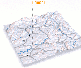 Places with similar names to Ŭnŏ-gol, Korea, North ::
Disclaimer :: Information on this page comes without warranty of any kind |
||
|
Where is Ŭnŏ-gol? Elevation and coordinates ::
Latitude (lat): 39°20'58"N Longitude (lon): 126°15'41"E
Elevation (approx.): 74m (map arrows pan, magnifying glasses zoom) |
||
|
Visiting Ŭnŏ-gol? Hotel/Accommodation ::
Book a hotel in Ŭnŏ-gol Travel Guide ::
rental cars ::
car rental offers GPS waypoint ::
download a GPX waypoint (PoI) of Ŭnŏ-gol for your GPS receiver
|
||