|
search place name
|
||
Usan (Hamgyŏng, Korea, North)Usan is a town in the Hamgyŏng region of Korea, North. An overview map of the region around Usan is displayed below.
regional and 3d topo map of Usan, Korea, North ::
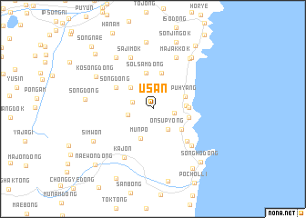
Nearby towns ::
Ch'ak-kol (2.0km north west) //
Samgi (2.1km east) //
Ch'omak (2.4km west) //
Onsup'yŏng (2.9km south east) //
Magamdŏk (3.3km north west) //
Munp'o (3.8km south) //
Udong-dong (3.1km east) //
Puhyang (3.3km north east) //
Hwangp'yŏng (3.7km south east) //
Uha (3.4km east) //
Changgong-gol (4.5km north) //
Solsam-dong (4.5km north) //
Ch'ujin (3.5km east) //
Chikkok (4.5km north) //
Sŏng-dong (4.3km north west) //
Hwangho (5.1km south east) //
Hwangjil-li (5.8km south east) //
Sajimok (6.6km north) //
Perakpawi-gol (6.7km north) //
Saebawi-gol (6.7km north) //
Majakkok (6.7km north) //
Kajŏn (6.5km south west) //
Soryanghwa (7.1km north east) //
Kuk-kol (7.2km north west) //
Myŏngt'origok (7.2km north east) //
Kosŏng-dong (6.6km north west) //
Changjŭngmok (8.2km north) //
Simwŏn (6.7km south west) //
Sŏng-dong (6.3km west) //
[all distances 'as the bird flies' and approximate] 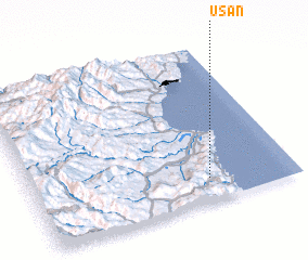 Places with similar names to Usan, Korea, North ::
Disclaimer :: Information on this page comes without warranty of any kind |
||
|
Where is Usan? Elevation and coordinates ::
Latitude (lat): 41°8'36"N Longitude (lon): 129°40'27"E
Elevation (approx.): 80m (map arrows pan, magnifying glasses zoom) |
||
|
Visiting Usan? Hotel/Accommodation ::
Book a hotel in Usan Travel Guide ::
rental cars ::
car rental offers GPS waypoint ::
download a GPX waypoint (PoI) of Usan for your GPS receiver
|
||