|
search place name
|
||
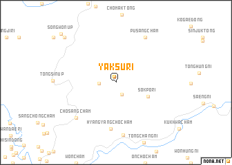
Yaksu-ri (Chagang, Korea, North)Yaksu-ri is a town in the Chagang region of Korea, North. An overview map of the region around Yaksu-ri is displayed below.
regional and 3d topo map of Yaksu-ri, Korea, North ::
Yaksu-ri airports ::
The nearest airport is FNJ - Pyongyang Intl, located 134.6 km south west of Yaksu-ri.
Nearby towns ::
Changhang-dong (2.1km south) //
Arongsŏng-ni (2.1km west) //
Sŏkp'o-ri (4.6km south east) //
Hyangyangch'och'am (7.6km south) //
Ch'osangch'am (7.5km south west) //
Kyŏnghŭng-ni (8.6km south) //
Pusangch'am (8.1km north east) //
Kaegogae-dong (9.6km north west) //
Yŏnmokch'am (9.6km north west) //
Songwŏn-ŭp (10.4km north west) //
[all distances 'as the bird flies' and approximate]  Places with similar names to Yaksu-ri, Korea, North ::
// Yegozero (RU)
// Yakassirou (BJ)
// Sierra Yaqui (MX)
// Yakka-Saray (UZ)
// Yekeh Sūr (IR)
// Yaguacire (HN)
// Yaksu-ri (KP)
// Yaksu-ri (KP)
// Yaksu-ri (KP)
// Yaksu-ri (KP)
Disclaimer :: Information on this page comes without warranty of any kind |
||
|
Where is Yaksu-ri? Elevation and coordinates ::
Latitude (lat): 40°18'5"N Longitude (lon): 126°23'28"E
Elevation (approx.): 320m (map arrows pan, magnifying glasses zoom) |
||
|
Visiting Yaksu-ri? Hotel/Accommodation ::
Book a hotel in Yaksu-ri Travel Guide ::
rental cars ::
car rental offers GPS waypoint ::
download a GPX waypoint (PoI) of Yaksu-ri for your GPS receiver
|
||