|
search place name
|
||
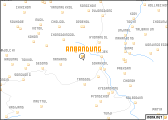
Anbandūng (Kangwŏn, Korea, South)Anbandūng is a town in the Kangwŏn region of Korea, South. An overview map of the region around Anbandūng is displayed below.
regional and 3d topo map of Anbandūng, Korea, South ::
Anbandūng airports ::
The nearest airport is KAG - Kangnung Gangneung, located 65.1 km north of Anbandūng.
Other airports nearby include YEC - Yechon Yecheon (79.6 km south west), SHO - Sokch'o Sokcho (112.7 km north), KPO - Pohang (137.4 km south), TAE - Taegu Daegu Ab (143.6 km south), Nearby towns ::
Anch'ungt'ŏ (2.4km north west) //
Taebaek (3.3km east) //
Sŏhakkol (3.5km south east) //
Pŏdŭlch'i (4.5km south east) //
Samgŏri (4.2km south east) //
Hyŏram-gol (4.8km north east) //
Manhang (4.2km west) //
Tang-gol (5.4km south) //
Chŏngdong-gol (5.8km north west) //
Anch'angjuk (7.4km north) //
Araemal (7.4km north) //
Chunggallae (7.3km north west) //
Chŏlgol (8.6km north west) //
Kyesan-dong (8.6km south east) //
Changsŏng-dong (8.8km south east) //
[all distances 'as the bird flies' and approximate] 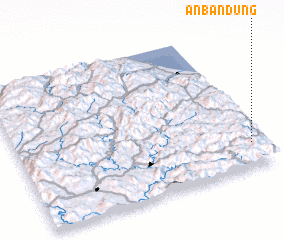 Places with similar names to Anbandūng, Korea, South ::
// Anbiantang (CN)
Disclaimer :: Information on this page comes without warranty of any kind |
||
|
Where is Anbandūng? Elevation and coordinates ::
Latitude (lat): 37°10'0"N Longitude (lon): 128°57'0"E
Elevation (approx.): 885m (map arrows pan, magnifying glasses zoom) |
||
|
Visiting Anbandūng? Hotel/Accommodation ::
Book a hotel in Anbandūng Travel Guide ::
rental cars ::
car rental offers GPS waypoint ::
download a GPX waypoint (PoI) of Anbandūng for your GPS receiver
|
||