|
search place name
|
||
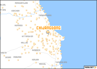
Chijang-dong (Kyŏngsang, Korea, South)Chijang-dong is a town in the Kyŏngsang region of Korea, South. An overview map of the region around Chijang-dong is displayed below.
regional and 3d topo map of Chijang-dong, Korea, South ::
Chijang-dong airports ::
The nearest airport is KAG - Kangnung Gangneung, located 84.4 km north west of Chijang-dong.
Other airports nearby include YEC - Yechon Yecheon (103.0 km south west), KPO - Pohang (120.6 km south), SHO - Sokch'o Sokcho (136.9 km north west), TAE - Taegu Daegu Ab (145.6 km south west), Nearby towns ::
Karisan (0.5km south west) //
Kodŭmi (0.6km east) //
Kujang-gol (0.7km north east) //
Saemal (1.1km north) //
Ha-dong (1.5km north west) //
Tongmak (1.7km south west) //
Simok-tong (1.5km east) //
Anma (1.5km east) //
Kigok-tong (1.5km east) //
Pyŏlchang-dong (1.9km south) //
Pŏmsang-gol (2.1km south) //
Kamnae-dong (2.2km south) //
Yongjang-dong (2.0km south east) //
T'oech'ŏn-dong (2.1km north east) //
Ungdŏng-gol (1.9km west) //
Konggun-dong (2.0km east) //
Chaeppŏmsang (2.6km south) //
Unma (2.4km south west) //
Mabun-dong (2.3km east) //
Susil (2.4km east) //
Sŏngnae-dong (2.7km south east) //
Sŏpsil (2.8km south west) //
Araenma (3.0km south west) //
Hahŭngbu-dong (3.4km north) //
Hŭngbu-dong (3.4km north) //
Maejŏng-dong (2.8km east) //
Sanghŭngbu-dong (3.3km north west) //
Tok-kol (2.9km north west) //
An-gol (3.6km south) //
[all distances 'as the bird flies' and approximate] 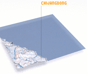 Places with similar names to Chijang-dong, Korea, South ::
// Ch'ajang-dong (KP)
// Ch'ajang-dong (KP)
// Chajŏng-dong (KP)
// Chajŏng-dong (KP)
// Chijang-dong (KP)
// Chijŏng-dong (KP)
// Ch'ojang-dong (KP)
// Chojŏng-dong (KP)
// Ch'ujang-dong (KP)
// Ch'ojung-dong (KP)
Disclaimer :: Information on this page comes without warranty of any kind |
||
|
Where is Chijang-dong? Elevation and coordinates ::
Latitude (lat): 37°4'25"N Longitude (lon): 129°22'16"E
Elevation (approx.): 42m (map arrows pan, magnifying glasses zoom) |
||
|
Visiting Chijang-dong? Hotel/Accommodation ::
Book a hotel in Chijang-dong Travel Guide ::
rental cars ::
car rental offers GPS waypoint ::
download a GPX waypoint (PoI) of Chijang-dong for your GPS receiver
|
||