|
search place name
|
||
Ch'ŏksal-li (Kyŏngsang, Korea, South)Ch'ŏksal-li is a town in the Kyŏngsang region of Korea, South. An overview map of the region around Ch'ŏksal-li is displayed below.
regional and 3d topo map of Ch'ŏksal-li, Korea, South ::

Ch'ŏksal-li airports ::
The nearest airport is KPO - Pohang, located 89.9 km south of Ch'ŏksal-li.
Other airports nearby include YEC - Yechon Yecheon (99.8 km west), KAG - Kangnung Gangneung (115.2 km north west), TAE - Taegu Daegu Ab (123.0 km south west), USN - Ulsan (134.0 km south), Nearby towns ::
Hasa-ri (2.1km north) //
Ukkomsil (2.7km north west) //
Sangsa-dong (4.1km north) //
Kusan (4.4km south) //
Chungda (4.3km west) //
Sagimak (5.1km south west) //
Wŏlsong (6.4km south) //
Mangyang (6.4km north west) //
Sanggabyul (6.4km west) //
P'yŏnghae (7.9km south) //
Piji-ri (6.9km west) //
Tongsamsan (7.9km north west) //
Chikkogae (8.8km south) //
P'yŏngjŏn (9.9km south west) //
[all distances 'as the bird flies' and approximate] 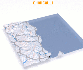 Places with similar names to Ch'ŏksal-li, Korea, South ::
// Shaykh Şāliḩ (IQ)
// Chak Saila (BD)
// Chacaicillo (CL)
// Shakazalo (CD)
// Chuxil (GT)
// Chikusela (ZM)
// Sheykhsīlū (IR)
// Chaccella (PE)
// Chuksal-li (KP)
// Chuksal-li (KP)
Disclaimer :: Information on this page comes without warranty of any kind |
||
|
Where is Ch'ŏksal-li? Elevation and coordinates ::
Latitude (lat): 36°47'53"N Longitude (lon): 129°27'8"E
Elevation (approx.): 8m (map arrows pan, magnifying glasses zoom) |
||
|
Visiting Ch'ŏksal-li? Hotel/Accommodation ::
Book a hotel in Ch'ŏksal-li Travel Guide ::
rental cars ::
car rental offers GPS waypoint ::
download a GPX waypoint (PoI) of Ch'ŏksal-li for your GPS receiver
|
||