|
search place name
|
||
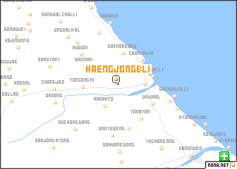
Haengjŏng 1-li (Kangwŏn, Korea, South)Haengjŏng 1-li is a town in the Kangwŏn region of Korea, South. An overview map of the region around Haengjŏng 1-li is displayed below.
regional and 3d topo map of Haengjŏng 1-li, Korea, South ::
Haengjŏng 1-li airports ::
The nearest airport is KAG - Kangnung Gangneung, located 17.6 km south east of Haengjŏng 1-li.
Other airports nearby include SHO - Sokch'o Sokcho (36.0 km north west), YEC - Yechon Yecheon (141.4 km south), SSN - Seoul East Seoul Ab (155.0 km west), OSN - Osan Ab (177.6 km south west), Nearby towns ::
Changdŏng-ni (2.2km north) //
Sadang-dong (3.3km north east) //
Maramt'ŏ (3.8km south west) //
Pangnae-ri (3.3km east) //
Koemae-dong (5.0km north) //
Chumunjin (4.8km north east) //
Yŏngjil-li (4.5km east) //
T'oegong-ni (4.5km west) //
Sagimak (5.0km north west) //
Ŭmji-mal (5.3km south east) //
Yŏnbyŏn (6.2km south east) //
Sagimang-ni (7.1km south) //
Muda-ri (6.6km north west) //
Un'gye-dong (8.2km south) //
Hwap'yŏng-dong (7.0km east) //
Yangchi-maŭl (8.6km north) //
Sach'ŏnjil-li (7.3km east) //
Hawŏlch'ŏn (8.5km north west) //
Such'ŏng-dong (8.9km south west) //
Ŭngdal-mal (9.8km north west) //
[all distances 'as the bird flies' and approximate] 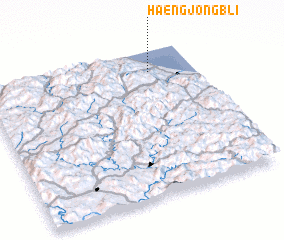 Places with similar names to Haengjŏng 1-li, Korea, South :: Disclaimer :: Information on this page comes without warranty of any kind |
||
|
Where is Haengjŏng 1-li? Elevation and coordinates ::
Latitude (lat): 37°51'24"N Longitude (lon): 128°47'33"E
Elevation (approx.): 60m (map arrows pan, magnifying glasses zoom) |
||
|
Visiting Haengjŏng 1-li? Hotel/Accommodation ::
Book a hotel in Haengjŏng 1-li Travel Guide ::
rental cars ::
car rental offers GPS waypoint ::
download a GPX waypoint (PoI) of Haengjŏng 1-li for your GPS receiver
|
||