|
search place name
|
||
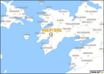
Haep'yŏng (Kyŏnggi, Korea, South)Haep'yŏng is a town in the Kyŏnggi region of Korea, South. An overview map of the region around Haep'yŏng is displayed below.
regional and 3d topo map of Haep'yŏng, Korea, South ::
Haep'yŏng airports ::
The nearest airport is OSN - Osan Ab, located 30.0 km east of Haep'yŏng.
Other airports nearby include GMP - Seoul Gimpo (44.0 km north), SSN - Seoul East Seoul Ab (47.5 km north east), KUB - Kunsan Ab (140.5 km south), YEC - Yechon Yecheon (158.6 km east), Nearby towns ::
Kurigae (2.3km north east) //
K'ŭn-mal (3.2km south) //
Apsil (3.6km north) //
Kurisŏm (3.7km south west) //
Songgyo-ri (3.6km west) //
Kungp'yŏng-ni (5.2km south) //
Tae-ch'on (4.7km north east) //
Ch'aegyŏng (5.4km north west) //
Sijang (5.7km north east) //
Kaegŏnnŏ (5.4km north east) //
Kanmaru (7.2km north) //
Masal-li (7.3km north) //
Suruji (6.6km east) //
Pangjungmŏri (7.2km north east) //
Masanp'o (8.4km north) //
Kojŏng-ni (9.0km north) //
Sŏn'gami (8.9km north west) //
Wŏnani (10.2km south east) //
[all distances 'as the bird flies' and approximate] 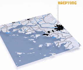 Places with similar names to Haep'yŏng, Korea, South ::
Disclaimer :: Information on this page comes without warranty of any kind |
||
|
Where is Haep'yŏng? Elevation and coordinates ::
Latitude (lat): 37°10'5"N Longitude (lon): 126°42'20"E
Elevation (approx.): 9m (map arrows pan, magnifying glasses zoom) |
||
|
Visiting Haep'yŏng? Hotel/Accommodation ::
Book a hotel in Haep'yŏng Travel Guide ::
rental cars ::
car rental offers GPS waypoint ::
download a GPX waypoint (PoI) of Haep'yŏng for your GPS receiver
|
||