|
search place name
|
||
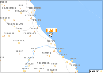
Hujin (Kangwŏn, Korea, South)Hujin is a town in the Kangwŏn region of Korea, South. An overview map of the region around Hujin is displayed below.
regional and 3d topo map of Hujin, Korea, South ::
Hujin airports ::
The nearest airport is KAG - Kangnung Gangneung, located 37.9 km north west of Hujin.
Other airports nearby include SHO - Sokch'o Sokcho (90.7 km north west), YEC - Yechon Yecheon (117.6 km south west), KPO - Pohang (165.3 km south), TAE - Taegu Daegu Ab (180.2 km south), Nearby towns ::
Ch'uam-ni (0.6km north west) //
Samch'ŏk (2.7km south) //
Chŏngha (3.3km south) //
Chŏngno-ri (5.4km south) //
Pongo-dong (5.3km north west) //
Songjŏng-ni (5.3km north west) //
Hanch'imit (5.8km south east) //
Pukp'yŏng (5.4km north west) //
Naan-ni (5.4km north west) //
Saebŏsil (7.1km south) //
Kobat-kol (7.2km south) //
Yongjŏng (6.8km north west) //
Chisang-dong (6.3km west) //
Tunjŏm (7.3km south west) //
Pon-ch'on (8.2km south east) //
Hanggok-tong (8.7km north west) //
P'yŏngnŭng (9.1km north west) //
Tonghae (10.6km north west) //
Hachŏng-ni (10.8km south west) //
[all distances 'as the bird flies' and approximate] 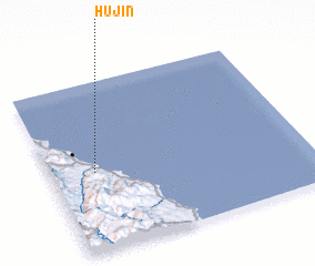 Places with similar names to Hujin, Korea, South ::
Disclaimer :: Information on this page comes without warranty of any kind |
||
|
Where is Hujin? Elevation and coordinates ::
Latitude (lat): 37°27'52"N Longitude (lon): 129°10'22"E
Elevation (approx.): 14m (map arrows pan, magnifying glasses zoom) |
||
|
Visiting Hujin? Hotel/Accommodation ::
Book a hotel in Hujin Travel Guide ::
rental cars ::
car rental offers GPS waypoint ::
download a GPX waypoint (PoI) of Hujin for your GPS receiver
|
||