|
search place name
|
||
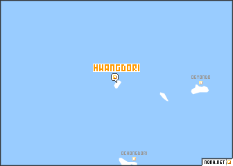
Hwangdo-ri (Ch'ungch'ŏng, Korea, South)Hwangdo-ri is a town in the Ch'ungch'ŏng region of Korea, South. An overview map of the region around Hwangdo-ri is displayed below.
regional and 3d topo map of Hwangdo-ri, Korea, South ::
Hwangdo-ri airports ::
The nearest airport is KUB - Kunsan Ab, located 69.3 km south east of Hwangdo-ri.
Other airports nearby include OSN - Osan Ab (134.9 km north east), KWJ - Kwangju Gwangju (144.7 km south east), GMP - Seoul Gimpo (164.7 km north east), SSN - Seoul East Seoul Ab (169.4 km north east), Nearby towns ::
[all distances 'as the bird flies' and approximate]  Places with similar names to Hwangdo-ri, Korea, South ::
Disclaimer :: Information on this page comes without warranty of any kind |
||
|
Where is Hwangdo-ri? Elevation and coordinates ::
Latitude (lat): 36°13'57"N Longitude (lon): 125°57'41"E
Elevation (approx.): 17m (map arrows pan, magnifying glasses zoom) |
||
|
Visiting Hwangdo-ri? Hotel/Accommodation ::
Book a hotel in Hwangdo-ri Travel Guide ::
rental cars ::
car rental offers GPS waypoint ::
download a GPX waypoint (PoI) of Hwangdo-ri for your GPS receiver
|
||