|
search place name
|
||
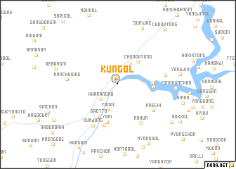
K'ŭn-gol (Kyŏnggi, Korea, South)K'ŭn-gol is a town in the Kyŏnggi region of Korea, South. An overview map of the region around K'ŭn-gol is displayed below.
regional and 3d topo map of K'ŭn-gol, Korea, South ::
K'ŭn-gol airports ::
The nearest airport is SSN - Seoul East Seoul Ab, located 38.1 km south west of K'ŭn-gol.
Other airports nearby include GMP - Seoul Gimpo (56.0 km west), OSN - Osan Ab (75.5 km south west), SHO - Sokch'o Sokcho (116.2 km north east), KAG - Kangnung Gangneung (136.3 km east), Nearby towns ::
Hwarangp'o (3.2km south west) //
Changgok-tong (3.6km north east) //
Ch'ŏngp'yŏng (3.6km north east) //
Ya-mal (4.2km south) //
Ch'ŏngp'yŏng (4.4km north east) //
Yangji-mal (4.5km east) //
Hoegol (4.5km east) //
Saett'ŏ (5.6km south west) //
Yami (6.1km south) //
Oesuip (6.7km south) //
Paech'i (6.1km south east) //
Nomun (6.8km south east) //
Kŭmjung (7.3km south west) //
Homyŏng-ni (6.2km east) //
Manch'widae (6.4km west) //
Surijae (9.3km north) //
Hanujae (9.1km south east) //
Ch'ook-tong (10.5km north east) //
[all distances 'as the bird flies' and approximate]  Places with similar names to K'ŭn-gol, Korea, South ::
Disclaimer :: Information on this page comes without warranty of any kind |
||
|
Where is K'ŭn-gol? Elevation and coordinates ::
Latitude (lat): 37°42'14"N Longitude (lon): 127°23'55"E
Elevation (approx.): 91m (map arrows pan, magnifying glasses zoom) |
||
|
Visiting K'ŭn-gol? Hotel/Accommodation ::
Book a hotel in K'ŭn-gol Travel Guide ::
rental cars ::
car rental offers GPS waypoint ::
download a GPX waypoint (PoI) of K'ŭn-gol for your GPS receiver
|
||