|
search place name
|
||
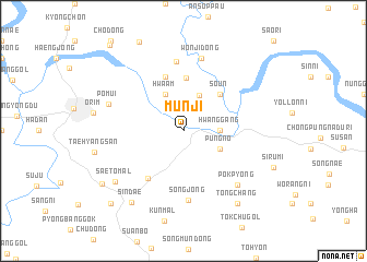
Munji (Ch'ungch'ŏng, Korea, South)Munji is a town in the Ch'ungch'ŏng region of Korea, South. An overview map of the region around Munji is displayed below.
regional and 3d topo map of Munji, Korea, South ::
Munji airports ::
The nearest airport is YEC - Yechon Yecheon, located 45.5 km south east of Munji.
Other airports nearby include OSN - Osan Ab (90.7 km west), SSN - Seoul East Seoul Ab (98.4 km north west), KAG - Kangnung Gangneung (120.2 km north east), GMP - Seoul Gimpo (129.3 km north west), Nearby towns ::
Hwanggang (3.0km east) //
Nŭng-gol (3.8km north) //
Hwaam (4.0km north) //
Pungno (3.5km south east) //
Sŏun (4.7km north east) //
Hŭngmok (5.5km north) //
Yangmok (5.8km north) //
Chin-mal (5.7km south west) //
Songjŏng (7.1km south) //
Tumusil (7.2km north) //
Wŏnji-dong (7.6km north) //
Pokp'yŏng (7.1km south east) //
Pŏmŭi (6.7km north west) //
Saet'ŏ-mal (7.6km south west) //
Sindae (8.5km south west) //
Tongch'ang (8.6km south east) //
Saesulmak (8.6km south west) //
Mudu-ri (9.5km south west) //
Kwanam (10.6km north west) //
[all distances 'as the bird flies' and approximate]  Places with similar names to Munji, Korea, South ::
Disclaimer :: Information on this page comes without warranty of any kind |
||
|
Where is Munji? Elevation and coordinates ::
Latitude (lat): 36°57'0"N Longitude (lon): 128°2'0"E
Elevation (approx.): 146m (map arrows pan, magnifying glasses zoom) |
||
|
Visiting Munji? Hotel/Accommodation ::
Book a hotel in Munji Travel Guide ::
rental cars ::
car rental offers GPS waypoint ::
download a GPX waypoint (PoI) of Munji for your GPS receiver
|
||