|
search place name
|
||
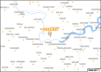
Naega-ri (Kyŏngsang, Korea, South)Naega-ri is a town in the Kyŏngsang region of Korea, South. An overview map of the region around Naega-ri is displayed below.
regional and 3d topo map of Naega-ri, Korea, South ::
Naega-ri airports ::
The nearest airport is TAE - Taegu Daegu Ab, located 66.2 km north east of Naega-ri.
Other airports nearby include RSU - Yeosu (88.5 km south west), PUS - Kimhae Gimhae Intl (89.9 km south east), USN - Ulsan (117.2 km east), YEC - Yechon Yecheon (122.7 km north), Nearby towns ::
Chungch'on (0.2km south) //
Ugok-tong (2.5km north east) //
Nop'a (2.9km north west) //
Sŏng-ni (3.3km south) //
Chunghwang-dong (4.5km south east) //
Hwanggye-ri (5.0km south) //
Panggong-ni (4.5km north east) //
Yongji-ri (4.7km east) //
Orim-dong (5.8km north west) //
Kasan-dong (5.6km south west) //
Kŭmgaek-tong (5.8km west) //
Sonmok-tong (5.8km east) //
Tŏk-tong (6.6km north west) //
Inggok (6.8km north east) //
Changjŏn-dong (6.8km south east) //
Sandu (7.6km south) //
Sulgok (6.8km west) //
Sulgong-ni (6.8km west) //
Kwan-dong (7.4km north east) //
Tusim (7.9km south west) //
P'alsim (8.3km north) //
Paegyŏk (10.4km south east) //
[all distances 'as the bird flies' and approximate]  Places with similar names to Naega-ri, Korea, South ::
Disclaimer :: Information on this page comes without warranty of any kind |
||
|
Where is Naega-ri? Elevation and coordinates ::
Latitude (lat): 35°33'8"N Longitude (lon): 128°3'35"E
Elevation (approx.): 117m (map arrows pan, magnifying glasses zoom) |
||
|
Visiting Naega-ri? Hotel/Accommodation ::
Book a hotel in Naega-ri Travel Guide ::
rental cars ::
car rental offers GPS waypoint ::
download a GPX waypoint (PoI) of Naega-ri for your GPS receiver
|
||