|
search place name
|
||
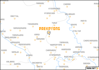
Paekpyŏng (Kyŏngsang, Korea, South)Paekpyŏng is a town in the Kyŏngsang region of Korea, South. An overview map of the region around Paekpyŏng is displayed below.
regional and 3d topo map of Paekpyŏng, Korea, South ::
Paekpyŏng airports ::
The nearest airport is YEC - Yechon Yecheon, located 70.5 km south west of Paekpyŏng.
Other airports nearby include KAG - Kangnung Gangneung (81.9 km north), KPO - Pohang (120.7 km south), TAE - Taegu Daegu Ab (127.9 km south), SHO - Sokch'o Sokcho (129.5 km north), Nearby towns ::
Hŭinbaengi (0.5km south) //
Tunji (4.0km north) //
Norumok (3.7km south west) //
Kan'gi (3.9km west) //
Hwangp'yŏng (5.0km south east) //
Chungbong (4.8km south west) //
Pyŏngo (6.5km north) //
Tarakkol (5.8km south east) //
Chandaemi (6.7km south) //
Tohwa-dong (6.0km north west) //
P'yŏngch'ŏn (7.4km north) //
Hyŏndong-ni (8.7km south) //
Hwangmok (8.2km south east) //
Malbadŭri (9.5km north east) //
Ŭiyang (10.6km south west) //
[all distances 'as the bird flies' and approximate] 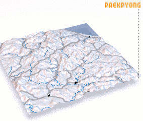 Places with similar names to Paekpyŏng, Korea, South ::
// Paekp'yŏng (KP)
// Paekp'yŏng (KR)
// Pokp'yŏng (KR)
// Pokp'yŏng (KR)
// Pokp'yŏng (KR)
// Pukp'yŏng (KR)
// Pukp'yŏng (KR)
// Paekp'yŏng (KP)
Disclaimer :: Information on this page comes without warranty of any kind |
||
|
Where is Paekpyŏng? Elevation and coordinates ::
Latitude (lat): 37°1'0"N Longitude (lon): 128°59'0"E
Elevation (approx.): 817m (map arrows pan, magnifying glasses zoom) |
||
|
Visiting Paekpyŏng? Hotel/Accommodation ::
Book a hotel in Paekpyŏng Travel Guide ::
rental cars ::
car rental offers GPS waypoint ::
download a GPX waypoint (PoI) of Paekpyŏng for your GPS receiver
|
||