|
search place name
|
||
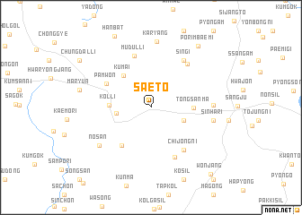
Saet'ŏ (Kyŏngsang, Korea, South)Saet'ŏ is a town in the Kyŏngsang region of Korea, South. An overview map of the region around Saet'ŏ is displayed below.
regional and 3d topo map of Saet'ŏ, Korea, South ::
Saet'ŏ airports ::
The nearest airport is YEC - Yechon Yecheon, located 35.6 km north east of Saet'ŏ.
Other airports nearby include TAE - Taegu Daegu Ab (78.7 km south east), OSN - Osan Ab (119.0 km north west), KPO - Pohang (130.9 km east), KUB - Kunsan Ab (142.0 km south west), Nearby towns ::
Kosil (2.5km north west) //
Nong-ch'on (3.6km south east) //
Naksŏ (3.6km west) //
Kumai (4.8km north west) //
Kolli (4.2km west) //
Tongsanma (4.3km east) //
Norusaet'ŏ (5.6km south west) //
Pamwŏn (5.4km north west) //
Chijŏng-ni (6.2km south east) //
Mudŭl-li (6.7km north) //
Winmoenae (6.7km south) //
Sin'gi (6.7km north east) //
Chappat (6.6km north east) //
Sinha-ri (6.2km east) //
Sinha-ri (6.4km east) //
Nosan (7.1km south west) //
Karyang (8.3km north) //
Pŏrimbaemi (9.0km north east) //
Hanbat (9.6km north) //
Wŏnjang (10.3km south east) //
[all distances 'as the bird flies' and approximate]  Places with similar names to Saet'ŏ, Korea, South ::
Disclaimer :: Information on this page comes without warranty of any kind |
||
|
Where is Saet'ŏ? Elevation and coordinates ::
Latitude (lat): 36°24'51"N Longitude (lon): 128°3'49"E
Elevation (approx.): 102m (map arrows pan, magnifying glasses zoom) |
||
|
Visiting Saet'ŏ? Hotel/Accommodation ::
Book a hotel in Saet'ŏ Travel Guide ::
rental cars ::
car rental offers GPS waypoint ::
download a GPX waypoint (PoI) of Saet'ŏ for your GPS receiver
|
||