|
search place name
|
||
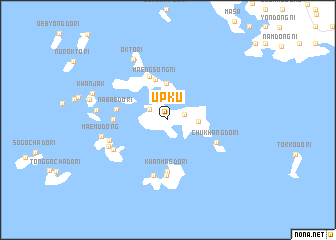
Ŭpku (Chŏlla, Korea, South)Ŭpku is a town in the Chŏlla region of Korea, South. An overview map of the region around Ŭpku is displayed below.
regional and 3d topo map of Ŭpku, Korea, South ::
Ŭpku airports ::
The nearest airport is CJU - Cheju Jeju Intl, located 95.5 km south east of Ŭpku.
Other airports nearby include KWJ - Kwangju Gwangju (115.9 km north east), RSU - Yeosu (156.2 km north east), KUB - Kunsan Ab (186.3 km north), Nearby towns ::
Ch'angyu-ri (0.9km north) //
Sillyung-ni (1.6km east) //
Konu (2.1km north west) //
Myŏngji (2.7km north) //
Sinjŏn (2.8km east) //
Tangdo (4.1km north) //
Maengsŏng-ni (4.7km north) //
Kakchinbawi (5.2km north) //
Kwanmaedo-ri (5.7km south) //
Nabaedo-ri (4.9km west) //
Chukhangdo-ri (5.1km south east) //
Modo-ri (5.0km west) //
Kwanmae-ri (6.2km south) //
Kwanho (6.3km south) //
Moryŏngi (6.0km south west) //
Taemado-ri (5.9km south west) //
Makkŭmi (6.2km south west) //
Maemu-dong (6.4km west) //
Okto-ri (7.5km north west) //
Somado-ri (6.7km west) //
Kwanjak (7.6km north west) //
Kwansado-ri (7.5km west) //
[all distances 'as the bird flies' and approximate]  Places with similar names to Ŭpku, Korea, South ::
Disclaimer :: Information on this page comes without warranty of any kind |
||
|
Where is Ŭpku? Elevation and coordinates ::
Latitude (lat): 34°17'22"N Longitude (lon): 126°3'6"E
Elevation (approx.): 11m (map arrows pan, magnifying glasses zoom) |
||
|
Visiting Ŭpku? Hotel/Accommodation ::
Book a hotel in Ŭpku Travel Guide ::
rental cars ::
car rental offers GPS waypoint ::
download a GPX waypoint (PoI) of Ŭpku for your GPS receiver
|
||