|
search place name
|
||
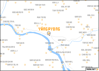
Yangp'yŏng (Kyŏnggi, Korea, South)Yangp'yŏng is a town in the Kyŏnggi region of Korea, South. An overview map of the region around Yangp'yŏng is displayed below.
regional and 3d topo map of Yangp'yŏng, Korea, South ::
Yangp'yŏng airports ::
The nearest airport is SSN - Seoul East Seoul Ab, located 33.7 km west of Yangp'yŏng.
Other airports nearby include OSN - Osan Ab (60.3 km south west), GMP - Seoul Gimpo (62.3 km west), SHO - Sokch'o Sokcho (121.5 km north east), YEC - Yechon Yecheon (122.4 km south east), Nearby towns ::
Yŏnyang (3.6km south) //
Okch'ŏl-li (4.0km north west) //
Tongch'ŏn (4.3km north) //
Sŏ-ch'on (5.0km north west) //
Toltam (5.0km south east) //
Wŏndŏk (4.6km south east) //
Asil-li (5.3km north west) //
Sesim (6.0km south) //
Puk-tong (6.4km north) //
Taegam (6.6km south) //
Puch'ŏul (6.6km south east) //
Changsu (6.8km east) //
Yŏnan (7.2km north east) //
Sangsim (6.8km west) //
Araejajin'gae (8.3km south east) //
Tumyŏngan (8.9km north) //
[all distances 'as the bird flies' and approximate] 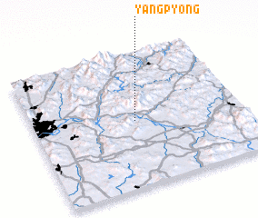 Places with similar names to Yangp'yŏng, Korea, South ::
// Yongp'yŏng (KP)
// Yŏngp'yŏng (KR)
// Yŏngp'yŏng (KR)
// Yŏngp'yŏng (KR)
// Yongup'yŏng (KP)
// Yŏngp'yŏng (KP)
Disclaimer :: Information on this page comes without warranty of any kind |
||
|
Where is Yangp'yŏng? Elevation and coordinates ::
Latitude (lat): 37°29'23"N Longitude (lon): 127°29'25"E
Elevation (approx.): 40m (map arrows pan, magnifying glasses zoom) |
||
|
Visiting Yangp'yŏng? Hotel/Accommodation ::
Book a hotel in Yangp'yŏng Travel Guide ::
rental cars ::
car rental offers GPS waypoint ::
download a GPX waypoint (PoI) of Yangp'yŏng for your GPS receiver
|
||