|
search place name
|
||
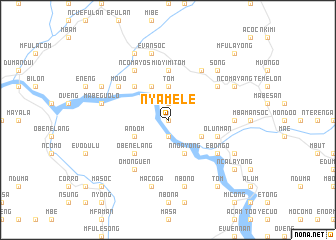
Nyamele (Equatorial Guinea)Nyamele is a town in Equatorial Guinea. An overview map of the region around Nyamele is displayed below.
regional and 3d topo map of Nyamele, Equatorial Guinea ::
Nyamele airports ::
The nearest airport is BSG - Bata, located 81.0 km west of Nyamele.
Other airports nearby include BMM - Bitam (108.5 km east), OYE - Oyem (123.1 km east), LBV - Libreville Leon M Ba (202.4 km south west), YAO - Yaounde Ville (240.7 km north east), Nearby towns ::
Elebelaba (0.0km north) //
Oveng (1.9km south) //
Ngo (1.9km north) //
Ensalga (1.9km north) //
Tom (3.7km north) //
San Carlos (4.1km north west) //
Cunoguono (4.1km north west) //
Nnoayong (4.1km south east) //
Andom (4.1km south west) //
Maseng (4.1km south east) //
Obenelang (5.2km south west) //
Mandoc (5.2km north west) //
Nco (5.2km south west) //
Midyimitom (5.6km north) //
Olun-Man (5.9km east) //
Miba-Menga (6.7km south east) //
Ebongo (6.7km south east) //
Mfaná (6.7km north east) //
Acam (6.7km south west) //
Omonguen (6.7km south west) //
Ncomayos (6.7km north west) //
Movo (6.7km north west) //
Kinbendag (6.7km north east) //
Mandame (7.4km east) //
Mabeguolo (7.6km west) //
Afansoc (7.6km south) //
Macoga (7.6km south) //
Evansoc (7.6km north) //
Nbono (7.6km south) //
[all distances 'as the bird flies' and approximate]  Places with similar names to Nyamele, Equatorial Guinea ::
Disclaimer :: Information on this page comes without warranty of any kind |
||
|
Where is Nyamele? Elevation and coordinates ::
Latitude (lat): 1°54'0"N Longitude (lon): 10°32'0"E
Elevation (approx.): 428m (map arrows pan, magnifying glasses zoom) |
||
|
Visiting Nyamele? Hotel/Accommodation ::
Book a hotel in Nyamele Travel Guide ::
rental cars ::
car rental offers GPS waypoint ::
download a GPX waypoint (PoI) of Nyamele for your GPS receiver
|
||