|
search place name
|
||
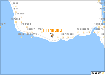
Atimaono (Polynésie Française, French Polynesia)Atimaono is a town in the Polynésie Française region of French Polynesia. An overview map of the region around Atimaono is displayed below.
regional and 3d topo map of Atimaono, French Polynesia ::
Atimaono airports ::
The nearest airport is MOZ - Moorea, located 43.8 km north west of Atimaono.
Other airports nearby include HUH - Huahine Island Huahine (204.0 km north west), RFP - Raiatea Island Raiatea (242.0 km north west), Nearby towns ::
Paparevo (1.8km east) //
Araiteva (1.8km east) //
Hatinua (3.5km east) //
Nairiri (3.5km east) //
Faremi (3.5km east) //
Apomaoro (4.0km north west) //
Terehe (4.0km north west) //
Otutara (5.3km east) //
Vaitunanaa (5.3km east) //
Mahaiutea (7.1km west) //
Otiaroa (7.1km east) //
Patere (7.3km west) //
[all distances 'as the bird flies' and approximate]  Places with similar names to Atimaono, French Polynesia ::
// Aït Teimane (MA)
// Atamna (MA)
// Attamna (MA)
// Atimon (PH)
// Adamów Nowy (PL)
// Adomynė (LT)
// Adamany (UA)
// Ataman (UA)
// Atmanay (UA)
// Ādīāmān (IR)
Disclaimer :: Information on this page comes without warranty of any kind |
||
|
Where is Atimaono? Elevation and coordinates ::
Latitude (lat): 17°46'0"S Longitude (lon): 149°28'0"W
Elevation (approx.): 14m (map arrows pan, magnifying glasses zoom) |
||
|
Visiting Atimaono? Hotel/Accommodation ::
Book a hotel in Atimaono Travel Guide ::
rental cars ::
car rental offers GPS waypoint ::
download a GPX waypoint (PoI) of Atimaono for your GPS receiver
|
||