|
search place name
|
||
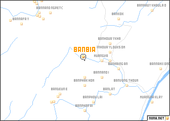
Ban Bia (Xaignabouli, Laos)Ban Bia is a town in the Xaignabouli region of Laos. An overview map of the region around Ban Bia is displayed below.
regional and 3d topo map of Ban Bia, Laos ::
Ban Bia airports ::
The nearest airport is LOE - Loei, located 104.4 km south east of Ban Bia.
Other airports nearby include PRH - Phrae (119.5 km west), VTE - Vientiane Wattay Intl (139.3 km east), UTH - Udon Thani (187.9 km south east), LPT - Lampang (188.1 km west), Nearby towns ::
Ban Kok Guan (3.7km south) //
Muang Va (3.5km east) //
Ban Na Noi (5.1km south east) //
Ban Pha Khom (5.6km south) //
Ban Phing Pai (5.3km east) //
Ban Houay Louk Som (5.6km east) //
Ban Houaykha (6.5km north east) //
Ban Hai Ngan (7.3km east) //
Ban Deune (9.1km south west) //
Ban Lat (9.1km south east) //
Ban Ponkham (9.8km south west) //
[all distances 'as the bird flies' and approximate] 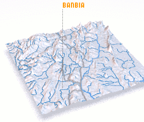 Places with similar names to Ban Bia, Laos ::
Disclaimer :: Information on this page comes without warranty of any kind |
||
|
Where is Ban Bia? Elevation and coordinates ::
Latitude (lat): 18°17'0"N Longitude (lon): 101°17'0"E
Elevation (approx.): 397m (map arrows pan, magnifying glasses zoom) |
||
|
Visiting Ban Bia? Hotel/Accommodation ::
Book a hotel in Ban Bia Travel Guide ::
Buy a travel guide for Laos rental cars ::
car rental offers GPS waypoint ::
download a GPX waypoint (PoI) of Ban Bia for your GPS receiver
|
||