|
search place name
|
||
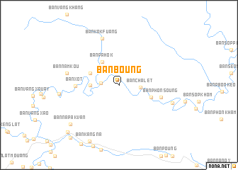
Ban Boung (Khammouan, Laos)Ban Boung is a town in the Khammouan region of Laos. An overview map of the region around Ban Boung is displayed below.
regional and 3d topo map of Ban Boung, Laos ::
Ban Boung airports ::
The nearest airport is SNO - Sakon Nakhon, located 141.5 km south west of Ban Boung.
Other airports nearby include ZVK - Savannakhet (194.9 km south), UTH - Udon Thani (232.7 km south west), Nearby towns ::
Ban Sôppon (2.7km west) //
Ban Chalèt (3.3km east) //
Ban Thaxang (4.3km west) //
Ban Pahôk (4.4km north west) //
Ban Chakou (4.6km north west) //
Ban Vanggnêng (5.2km east) //
Ban Xot (6.5km west) //
Ban Phônsoung (6.6km east) //
Ban Kôkfuang (7.8km north) //
Ban Namkou (8.0km west) //
Ban Kaan (8.5km east) //
Ban Napakvan (9.5km south west) //
Ban Kang-Na (9.9km south west) //
Ban Phônmuang (10.7km south west) //
Ban Pakha (11.0km south west) //
[all distances 'as the bird flies' and approximate]  Places with similar names to Ban Boung, Laos ::
// Banbanuag (PH)
// Binabang (PH)
// Banī Bānūk (IQ)
// Ban Baeng (TH)
// Ban Baeng (TH)
// Ban Ba Ing (TH)
// Ban Bang Hak (TH)
// Ban Bang Hak (TH)
// Ban Ba Ngo (TH)
// Ban Bang O (TH)
Disclaimer :: Information on this page comes without warranty of any kind |
||
|
Where is Ban Boung? Elevation and coordinates ::
Latitude (lat): 18°19'2"N Longitude (lon): 104°45'26"E
Elevation (approx.): 430m (map arrows pan, magnifying glasses zoom) |
||
|
Visiting Ban Boung? Hotel/Accommodation ::
Book a hotel in Ban Boung Travel Guide ::
Buy a travel guide for Laos rental cars ::
car rental offers GPS waypoint ::
download a GPX waypoint (PoI) of Ban Boung for your GPS receiver
|
||