|
search place name
|
||
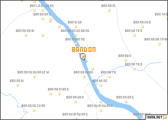
Ban Don (Laos)Ban Don is a town in Laos. An overview map of the region around Ban Don is displayed below.
regional and 3d topo map of Ban Don, Laos ::
Ban Don airports ::
The nearest airport is SNO - Sakon Nakhon, located 82.9 km south of Ban Don.
Other airports nearby include ZVK - Savannakhet (161.7 km south), UTH - Udon Thani (166.5 km west), VTE - Vientiane Wattay Intl (178.8 km west), Nearby towns ::
Ban Nanam (2.6km south east) //
Ban Na Khe (1) (3.7km south) //
Ban Phaeng (4.1km north west) //
Ban Boungkoang (5.8km north) //
Ban Mèng (6.6km south east) //
Ban Na Ta (6.5km south east) //
Ban Sida (7.6km north) //
Ban Na Riang (9.1km south west) //
Ban Hua Hat (9.1km north west) //
Ban Khok Phathai (10.2km south west) //
Ban Pho Sai (11.3km north west) //
[all distances 'as the bird flies' and approximate] 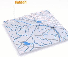 Places with similar names to Ban Don, Laos ::
Disclaimer :: Information on this page comes without warranty of any kind |
||
|
Where is Ban Don? Elevation and coordinates ::
Latitude (lat): 17°56'0"N Longitude (lon): 104°15'0"E
Elevation (approx.): 139m (map arrows pan, magnifying glasses zoom) |
||
|
Visiting Ban Don? Hotel/Accommodation ::
Book a hotel in Ban Don Travel Guide ::
Buy a travel guide for Laos rental cars ::
car rental offers GPS waypoint ::
download a GPX waypoint (PoI) of Ban Don for your GPS receiver
|
||