|
search place name
|
||
Ban Gnouan (Xiangkhoang, Laos)Ban Gnouan is a town in the Xiangkhoang region of Laos. An overview map of the region around Ban Gnouan is displayed below.
regional and 3d topo map of Ban Gnouan, Laos ::

Ban Gnouan airports ::
The nearest airport is LPQ - Luang Prabang Luang Phabang Intl, located 116.2 km north west of Ban Gnouan.
Other airports nearby include VTE - Vientiane Wattay Intl (179.8 km south), Nearby towns ::
Ban Len (2.4km south east) //
Ban Si (2) (3.7km north) //
Ban Bi (3.5km east) //
Ban Nakat (2) (3.8km south) //
Ban Ngôy (4.3km south) //
Ban Phai Khanh (4.3km south west) //
Ban Namon (4.3km south west) //
Ban Li (4.4km south west) //
Ban Bon (4.3km south west) //
Ban Fat (4.6km north east) //
Ban Nong (4.8km north east) //
Ban Khay (2) (4.8km north east) //
Ban Louang (4.8km north east) //
Ban Phônsavan (5.1km south east) //
Ban Nhieu (5.3km north west) //
Ban Nafèng (5.5km south) //
Ban Nangoy (5.6km south) //
Ban Naxoy (5.8km south) //
Ban Kat (5.8km south) //
Nahoy (5.8km south west) //
Sala Ban Sout (5.9km west) //
Ban Naboua (5.9km west) //
Ban Tang (5.9km west) //
Ban Xang (6.1km north east) //
Ban Napha (6.3km north east) //
Ban Viang (6.3km north east) //
Ban Naviang (6.3km north east) //
Ban Poung (1) (6.3km north east) //
Muang Kat (6.5km south east) //
[all distances 'as the bird flies' and approximate] 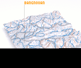 Places with similar names to Ban Gnouan, Laos ::
// Banganan (PH)
// Binauganan (PH)
// Ban Gnan (LA)
// Ban Gnon (LA)
// Ban Gnouana (LA)
// Ban Gnoun (LA)
// Ban Nagnon (LA)
// Bankonina (ML)
// Bankonina (ML)
// Ben ʼAknoûn (DZ)
Disclaimer :: Information on this page comes without warranty of any kind |
||
|
Where is Ban Gnouan? Elevation and coordinates ::
Latitude (lat): 19°30'2"N Longitude (lon): 103°11'11"E
Elevation (approx.): 1107m (map arrows pan, magnifying glasses zoom) |
||
|
Visiting Ban Gnouan? Hotel/Accommodation ::
Book a hotel in Ban Gnouan Travel Guide ::
Buy a travel guide for Laos rental cars ::
car rental offers GPS waypoint ::
download a GPX waypoint (PoI) of Ban Gnouan for your GPS receiver
|
||