|
search place name
|
||
Ban Hatliliap (Laos)Ban Hatliliap is a town in Laos. An overview map of the region around Ban Hatliliap is displayed below.
regional and 3d topo map of Ban Hatliliap, Laos ::

Ban Hatliliap airports ::
The nearest airport is THL - Tachilek Tachileik, located 84.3 km north west of Ban Hatliliap.
Other airports nearby include MOG - Mong Hsat (151.7 km west), LPQ - Luang Prabang Luang Phabang Intl (160.1 km east), KET - Kengtung (167.3 km north west), PRH - Phrae (227.0 km south), Nearby towns ::
Ban Khmou (6.3km south west) //
Ban Paktha (6.4km south west) //
Ban Maknat (6.5km east) //
Ban Houaykhiou (6.8km south west) //
Ban Houaythong (6.8km north west) //
Ban San (6.7km west) //
Ban Hatkham (6.8km north east) //
Ban Pakhat (7.4km east) //
Ban Phakhoy (7.9km south) //
Ban Padoy (8.1km south east) //
Ban Houaymak (9.2km north west) //
Ban Donchai (9.1km north east) //
Ban Hatfak (9.5km north east) //
Ban Khôk-Louang (9.6km north west) //
Ban Hatli (9.7km north east) //
Ban Houaysouak (10.6km south west) //
Ban Phouthô (11.2km south east) //
[all distances 'as the bird flies' and approximate] 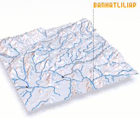 Places with similar names to Ban Hatliliap, Laos :: Disclaimer :: Information on this page comes without warranty of any kind |
||
|
Where is Ban Hatliliap? Elevation and coordinates ::
Latitude (lat): 20°7'48"N Longitude (lon): 100°39'2"E
Elevation (approx.): 370m (map arrows pan, magnifying glasses zoom) |
||
|
Visiting Ban Hatliliap? Hotel/Accommodation ::
Book a hotel in Ban Hatliliap Travel Guide ::
Buy a travel guide for Laos rental cars ::
car rental offers GPS waypoint ::
download a GPX waypoint (PoI) of Ban Hatliliap for your GPS receiver
|
||