|
search place name
|
||
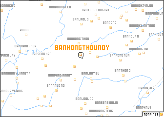
Ban Hongthou-Noy (Louangphrabang, Laos)Ban Hongthou-Noy is a town in the Louangphrabang region of Laos. An overview map of the region around Ban Hongthou-Noy is displayed below.
regional and 3d topo map of Ban Hongthou-Noy, Laos ::
Ban Hongthou-Noy airports ::
The nearest airport is LPQ - Luang Prabang Luang Phabang Intl, located 55.7 km south of Ban Hongthou-Noy.
Nearby towns ::
Ban Hongthou-Gnai (2.2km north east) //
Ban Sènxai (2.5km south west) //
Ban Hongthou (3.4km north) //
Ban Sènlouang (3.3km east) //
Ban Laoyeu (4.9km south east) //
Ban Houayxin-Nua (5.1km south) //
Ban Laolao (5.8km south) //
Ban Phadan-Noy (6.7km south west) //
Ban Houaylai (7.4km west) //
Ban Laolô (7.9km north) //
Ban Phadan-Gnai (8.0km west) //
Ban Pong-Nua (8.2km east) //
Ban Tôngtou-Noy (8.8km north) //
Ban Padông (9.2km south west) //
Ban Pong (9.3km north east) //
Ban Phadan-Noy (11.7km south west) //
[all distances 'as the bird flies' and approximate] 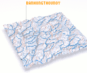 Places with similar names to Ban Hongthou-Noy, Laos :: Disclaimer :: Information on this page comes without warranty of any kind |
||
|
Where is Ban Hongthou-Noy? Elevation and coordinates ::
Latitude (lat): 20°24'3"N Longitude (lon): 102°8'54"E
Elevation (approx.): 1251m (map arrows pan, magnifying glasses zoom) |
||
|
Visiting Ban Hongthou-Noy? Hotel/Accommodation ::
Book a hotel in Ban Hongthou-Noy Travel Guide ::
Buy a travel guide for Laos rental cars ::
car rental offers GPS waypoint ::
download a GPX waypoint (PoI) of Ban Hongthou-Noy for your GPS receiver
|
||