|
search place name
|
||
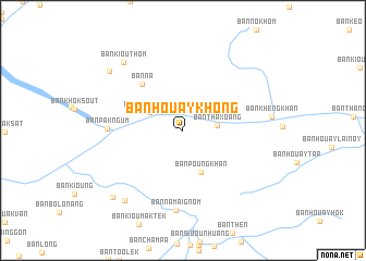
Ban Houaykhông (Xaignabouli, Laos)Ban Houaykhông is a town in the Xaignabouli region of Laos. An overview map of the region around Ban Houaykhông is displayed below.
regional and 3d topo map of Ban Houaykhông, Laos ::
Ban Houaykhông airports ::
The nearest airport is LPQ - Luang Prabang Luang Phabang Intl, located 88.0 km east of Ban Houaykhông.
Other airports nearby include THL - Tachilek Tachileik (163.2 km north west), PRH - Phrae (222.7 km south west), VTE - Vientiane Wattay Intl (240.5 km south east), KET - Kengtung (241.2 km north west), Nearby towns ::
Ban Thaxoang (3.3km east) //
Ban Houayxong (3.7km north west) //
Ban Houaylao (4.2km north west) //
Ban Poungkhan (4.7km south) //
Ban Na (6.2km north west) //
Ban Pakngum (7.3km west) //
Ban Namaignôm (8.2km south) //
Ban Kiouthôm (9.0km north west) //
Ban Houaykhai-Tai (9.1km south west) //
Ban Pholak (9.3km north west) //
Ban Houaykhai-Nua (9.7km south west) //
[all distances 'as the bird flies' and approximate] 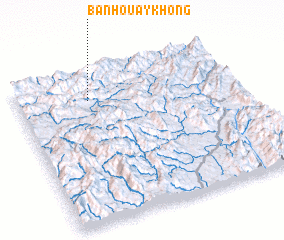 Places with similar names to Ban Houaykhông, Laos ::
// Ban Hoi Khong (TH)
// Ban Hoi Khong (TH)
// Ban Huai Khang (TH)
// Ban Huai Khiang (TH)
// Ban Huai Khi Nok (TH)
// Ban Huai Khong (TH)
// Ban Huai Khong (TH)
// Ban Hua Khung (TH)
// Ban Hua Khung (TH)
// Ban Houakhang (LA)
Disclaimer :: Information on this page comes without warranty of any kind |
||
|
Where is Ban Houaykhông? Elevation and coordinates ::
Latitude (lat): 19°48'49"N Longitude (lon): 101°19'31"E
Elevation (approx.): 635m (map arrows pan, magnifying glasses zoom) |
||
|
Visiting Ban Houaykhông? Hotel/Accommodation ::
Book a hotel in Ban Houaykhông Travel Guide ::
Buy a travel guide for Laos rental cars ::
car rental offers GPS waypoint ::
download a GPX waypoint (PoI) of Ban Houaykhông for your GPS receiver
|
||