|
search place name
|
||
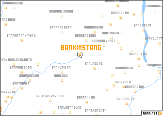
Ban Kimstang (Xaignabouli, Laos)Ban Kimstang is a town in the Xaignabouli region of Laos. An overview map of the region around Ban Kimstang is displayed below.
regional and 3d topo map of Ban Kimstang, Laos ::
Ban Kimstang airports ::
The nearest airport is THL - Tachilek Tachileik, located 90.6 km north west of Ban Kimstang.
Other airports nearby include MOG - Mong Hsat (146.7 km north west), LPQ - Luang Prabang Luang Phabang Intl (178.6 km east), KET - Kengtung (184.1 km north west), PRH - Phrae (190.4 km south), Nearby towns ::
Ban Laocho (3.7km south east) //
Ban Seng Choi (4.2km north) //
Ban Huai Han (5.4km south west) //
Ban Houaykhât (5.6km north east) //
Ban Huai Han (6.6km north east) //
Ban Lao U (6.7km south west) //
Ban Pang Bo Tai (7.3km north west) //
Ban Huai Khu (7.3km north west) //
Ban Dông (7.7km south east) //
Ban Tinpha (8.0km north east) //
Ban Houaychang (8.7km north east) //
Ban Houaylao (9.1km south east) //
Ban Mai (9.4km south east) //
Ban Kan Chai (10.0km north east) //
[all distances 'as the bird flies' and approximate] 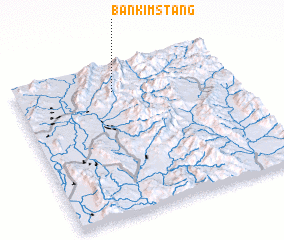 Places with similar names to Ban Kimstang, Laos :: Disclaimer :: Information on this page comes without warranty of any kind |
||
|
Where is Ban Kimstang? Elevation and coordinates ::
Latitude (lat): 19°49'47"N Longitude (lon): 100°27'25"E
Elevation (approx.): 893m (map arrows pan, magnifying glasses zoom) |
||
|
Visiting Ban Kimstang? Hotel/Accommodation ::
Book a hotel in Ban Kimstang Travel Guide ::
Buy a travel guide for Laos rental cars ::
car rental offers GPS waypoint ::
download a GPX waypoint (PoI) of Ban Kimstang for your GPS receiver
|
||