|
search place name
|
||
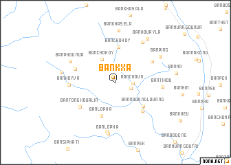
Ban Kxa (Phôngsali, Laos)Ban Kxa is a town in the Phôngsali region of Laos. An overview map of the region around Ban Kxa is displayed below.
regional and 3d topo map of Ban Kxa, Laos ::
Ban Kxa airports ::
The nearest airport is THL - Tachilek Tachileik, located 265.3 km south west of Ban Kxa.
Nearby towns ::
Ban Donchay (2.5km east) //
Ban Choun (2.7km east) //
Ban Chohoy (4.2km north west) //
Ban Chohoy (5.8km north) //
Ban Nadanglouang (5.6km south east) //
Ban Lopha (5.9km south) //
Hoang Phya (6.2km south east) //
Ban Khang (6.5km north east) //
Ban Phangsan (6.5km west) //
Ban Tôngkoualin (6.6km south west) //
Ban Hoyva (7.0km west) //
Ban Tihou (7.1km east) //
Ban Khasela (2) (7.7km north east) //
Ban Phou-Nua (7.6km north west) //
Ban Houayka (8.1km south) //
Ban Lo Pha (8.4km south) //
Ban Khasela (8.4km north) //
Ban Ping (8.0km north east) //
Ban Houayla (8.6km north east) //
Ban Takachin (8.3km west) //
[all distances 'as the bird flies' and approximate] 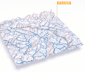 Places with similar names to Ban Kxa, Laos ::
// Bangcusay (PH)
// Ban Kok Sai (TH)
// Ban Kok Sai (TH)
// Ban Kok Siu (TH)
// Ban Kok So (TH)
// Bango Kas (PK)
// Ban Kaxa (LA)
// Ban Kiouxè (LA)
// Ban Nakaxo (LA)
// Bangxi (CN)
Disclaimer :: Information on this page comes without warranty of any kind |
||
|
Where is Ban Kxa? Elevation and coordinates ::
Latitude (lat): 22°13'29"N Longitude (lon): 101°41'37"E
Elevation (approx.): 1049m (map arrows pan, magnifying glasses zoom) |
||
|
Visiting Ban Kxa? Hotel/Accommodation ::
Book a hotel in Ban Kxa Travel Guide ::
Buy a travel guide for Laos rental cars ::
car rental offers GPS waypoint ::
download a GPX waypoint (PoI) of Ban Kxa for your GPS receiver
|
||